
Frenchville topographic map
Interactive map
Click on the map to display elevation.
About this map
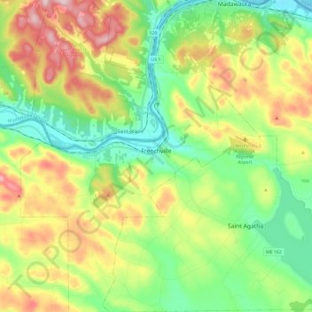
Name: Frenchville topographic map, elevation, terrain.
Location: Frenchville, Aroostook County, Maine, 04745, United States (47.19917 -68.48186 47.35724 -68.30261)
Average elevation: 252 m
Minimum elevation: 133 m
Maximum elevation: 450 m
Other topographic maps
Click on a map to view its topography, its elevation and its terrain.
Ashland
United States > Maine > Aroostook County
Ashland, Aroostook County, Maine, United States
Average elevation: 210 m
Castle Hill
United States > Maine > Aroostook County
Castle Hill, Aroostook County, Maine, United States
Average elevation: 216 m