Geolocate

Chame topographic map

Interactive map

Click on the map to display elevation.

About this map

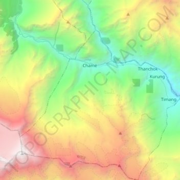
Name: Chame topographic map, elevation, terrain.

Location: Chame, मनाङ, Gandaki, Népal (28.47093 84.18697 28.59617 84.32763)

Average elevation: 4,177 m

Minimum elevation: 2,305 m

Maximum elevation: 6,972 m

Other topographic maps

Click on a map to view its topography, its elevation and its terrain.

Thoche

Népal > मनाङ

Thoche, Nashong, मनाङ, Gandaki, Népal

Average elevation: 4,922 m

Ghyaru

Népal > मनाङ > Nyawal

Ghyaru, Nyawal, Neshyang, मनाङ, Gandaki, Népal

Average elevation: 3,983 m

Dharapani

Népal > मनाङ > Dharapani

Dharapani, Nashong, मनाङ, Gandaki Pradesh, Népal

Average elevation: 3,706 m

Khansar

Népal > मनाङ

Khansar, Neshyang, मनाङ, Gandaki, Népal

Average elevation: 5,279 m

Manang

Népal > मनाङ > Manang

Manang, Neshyang, मनाङ, Gandaki Pradesh, Népal

Average elevation: 4,766 m