
Make a donation
Gear up for your next adventure:
As an Amazon Associate, this site earns from qualifying purchases at no extra cost to you.
West Yorkshire topographic map
Click on the map to display elevation.
Make a donation
Gear up for your next adventure:
As an Amazon Associate, this site earns from qualifying purchases at no extra cost to you.
West Yorkshire
Wakefield's Parish Church was raised to cathedral status in 1888 and after the elevation of Wakefield to diocese, Wakefield Council immediately sought city status and this was granted in July 1888. However the Industrial Revolution, which changed West and South Yorkshire significantly, led to the growth of Leeds and Bradford, which became the area's two largest cities (Leeds being the largest in Yorkshire). Leeds was granted city status in 1893 and Bradford in 1897. The name of Leeds Town Hall reflects the fact that at its opening in 1858 Leeds was not yet a city, while Bradford renamed its Town Hall as City Hall in 1965.
Make a donation
Gear up for your next adventure:
As an Amazon Associate, this site earns from qualifying purchases at no extra cost to you.
About this map
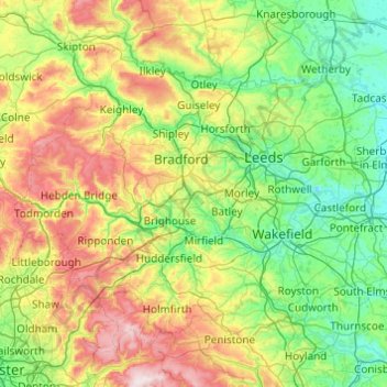
Name: West Yorkshire topographic map, elevation, terrain.
Location: West Yorkshire, England, United Kingdom (53.51973 -2.17329 53.96315 -1.19881)
Average elevation: 172 m
Minimum elevation: 4 m
Maximum elevation: 632 m
Make a donation
Gear up for your next adventure:
As an Amazon Associate, this site earns from qualifying purchases at no extra cost to you.
Other topographic maps
Click on a map to view its topography, its elevation and its terrain.
City of London
United Kingdom > England > City of London > City of London
The elevation of the City ranges from sea level at the Thames to 21.6 metres (71 ft) at the junction of High Holborn and Chancery Lane. Two small but notable hills are within the historic core, Ludgate Hill to the west and Cornhill to the east. Between them ran the Walbrook, one of the many "lost" rivers or…
Average elevation: 42 m
Birmingham
United Kingdom > England > Birmingham
Birmingham is a snowy city relative to other large UK conurbations, due to its inland location and comparatively high elevation. Between 1961 and 1990 Birmingham Airport averaged 13.0 days of snow lying annually, compared to 5.33 at London Heathrow. Snow showers often pass through the city via the Cheshire gap…
Average elevation: 130 m
Make a donation
Gear up for your next adventure:
As an Amazon Associate, this site earns from qualifying purchases at no extra cost to you.
Shrewsbury
United Kingdom > England > Shrewsbury
Shrewsbury is about 14 miles (23 km) west of Telford, 43 miles (69 km) west of Birmingham and the West Midlands Conurbation, and about 153 miles (246 km) north-west of the capital, London. More locally, the town is to the east of Welshpool, with Bridgnorth and Kidderminster to the south-east. The border with…
Average elevation: 71 m
Make a donation
Gear up for your next adventure:
As an Amazon Associate, this site earns from qualifying purchases at no extra cost to you.
Bury St Edmunds
United Kingdom > England > Bury St Edmunds
The name Bury is etymologically connected with borough, which has cognates in other Germanic languages such as the German burg meaning "fortress, castle"; Old Norse borg meaning "wall, castle"; and Gothic baurgs meaning "city". They all derive from Proto-Germanic *burgs meaning "fortress". This in turn derives…
Average elevation: 59 m
Make a donation
Gear up for your next adventure:
As an Amazon Associate, this site earns from qualifying purchases at no extra cost to you.
Newbury
United Kingdom > England > Newbury
Elevations vary from a minimum of 72m above mean sea level to 122m at Wash Common. Elevations reach 150-200m in the directly adjoining hills.
Average elevation: 102 m
Make a donation
Gear up for your next adventure:
As an Amazon Associate, this site earns from qualifying purchases at no extra cost to you.
Aylesbury
United Kingdom > England > Aylesbury
Aylesbury is immediately southeast of the upper River Thame that flows past Thame to Dorchester on Thames and is partly sited on the two northernmost outcrops of Portland (lime)stone in England bisected by a small stream, Bear Brook which gives a relatively prominent position in relation to the terrain of all…
Average elevation: 84 m
Make a donation
Gear up for your next adventure:
As an Amazon Associate, this site earns from qualifying purchases at no extra cost to you.
Make a donation
Gear up for your next adventure:
As an Amazon Associate, this site earns from qualifying purchases at no extra cost to you.
Make a donation
Gear up for your next adventure:
As an Amazon Associate, this site earns from qualifying purchases at no extra cost to you.
Make a donation
Gear up for your next adventure:
As an Amazon Associate, this site earns from qualifying purchases at no extra cost to you.
Make a donation
Gear up for your next adventure:
As an Amazon Associate, this site earns from qualifying purchases at no extra cost to you.
Make a donation
Gear up for your next adventure:
As an Amazon Associate, this site earns from qualifying purchases at no extra cost to you.
Make a donation
Gear up for your next adventure:
As an Amazon Associate, this site earns from qualifying purchases at no extra cost to you.
Sudeley Castle
United Kingdom > England > Gloucestershire > Cheltenham > Sudeley
His elevation almost certainly came from his assistance in the suppression of the Wyatt rebellion.
Average elevation: 135 m
Make a donation
Gear up for your next adventure:
As an Amazon Associate, this site earns from qualifying purchases at no extra cost to you.
Make a donation
Gear up for your next adventure:
As an Amazon Associate, this site earns from qualifying purchases at no extra cost to you.
Pendragon Castle
United Kingdom > England > Westmorland and Furness > Outhgill
Average elevation: 345 m
Make a donation
Gear up for your next adventure:
As an Amazon Associate, this site earns from qualifying purchases at no extra cost to you.
Coppull
United Kingdom > England > Lancashire > Chorley
The settlement has an Anglo Saxon name describing its topography derived from the Old English copp a hill top and hyll a hill. The township was variously recorded as Cophull and Cophulle in 1277, Copphull in 1351, Copthull in 1374 and Coppull from 1444.
Average elevation: 79 m
Make a donation
Gear up for your next adventure:
As an Amazon Associate, this site earns from qualifying purchases at no extra cost to you.
Bebington
Bebington is on the eastern side of the Wirral Peninsula, approximately 10 km (6.2 mi) south-south-east of the Irish Sea at New Brighton, about 7.5 km (4.7 mi) east-north-east of the Dee Estuary at Gayton and less than 2 km (1.2 mi) west-north-west of the River Mersey at New Ferry. The area is situated at an…
Average elevation: 28 m
Nelson Park
United Kingdom > England > Kent > Dover > St. Margaret's at Cliffe
Average elevation: 69 m
Make a donation
Gear up for your next adventure:
As an Amazon Associate, this site earns from qualifying purchases at no extra cost to you.
Bedford
United Kingdom > England > Bedford
As with the rest of the United Kingdom, Bedford has a maritime climate, with a limited range of temperatures, and generally even rainfall throughout the year. The nearest Met Office weather station to Bedford is Bedford (Thurleigh) airport, about 6.5 miles (10.5 km) north of Bedford town centre at an elevation…
Average elevation: 37 m
Make a donation
Gear up for your next adventure:
As an Amazon Associate, this site earns from qualifying purchases at no extra cost to you.
Make a donation
Gear up for your next adventure:
As an Amazon Associate, this site earns from qualifying purchases at no extra cost to you.
Make a donation
Gear up for your next adventure:
As an Amazon Associate, this site earns from qualifying purchases at no extra cost to you.
Make a donation
Gear up for your next adventure:
As an Amazon Associate, this site earns from qualifying purchases at no extra cost to you.
Make a donation
Gear up for your next adventure:
As an Amazon Associate, this site earns from qualifying purchases at no extra cost to you.
White Cross
United Kingdom > England > Devon > Mid Devon > Cheriton Fitzpaine
Average elevation: 131 m
Make a donation
Gear up for your next adventure:
As an Amazon Associate, this site earns from qualifying purchases at no extra cost to you.
Make a donation
Gear up for your next adventure:
As an Amazon Associate, this site earns from qualifying purchases at no extra cost to you.
Make a donation
Gear up for your next adventure:
As an Amazon Associate, this site earns from qualifying purchases at no extra cost to you.
Make a donation
Gear up for your next adventure:
As an Amazon Associate, this site earns from qualifying purchases at no extra cost to you.