
Anclote topographic map
Click on the map to display elevation.
About this map
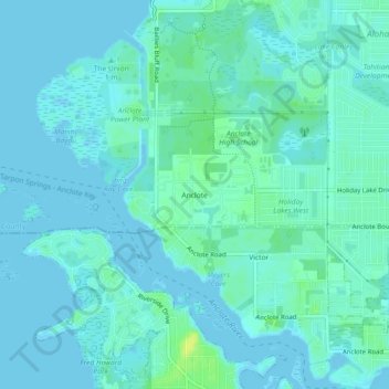
Name: Anclote topographic map, elevation, terrain.
Location: Anclote, Pasco County, Florida, 34691, United States (28.15612 -82.80066 28.19612 -82.76066)
Average elevation: 4 m
Minimum elevation: -2 m
Maximum elevation: 16 m
Other topographic maps
Click on a map to view its topography, its elevation and its terrain.
Dade City
United States > Florida > Pasco County
Dade City contains gently rolling topography with elevations from 60 ft to 100 ft.
Average elevation: 33 m
Wesley Chapel
United States > Florida > Pasco County
According to the United States Census Bureau, the CDP has a total area of 6.1 square miles (16 km2), of which 6.1 square miles (16 km2) is land and 0.04 square miles (0.10 km2) (0.49%) is water. The elevation is about 100 feet (30 m), combined with an inland location, creates more temperature variation in the…
Average elevation: 19 m
Saint Leo
United States > Florida > Pasco County
St. Leo contains rolling hills with elevations from 100 ft to 180 ft.
Average elevation: 46 m