
Daneș topographic map
Interactive map
Click on the map to display elevation.
About this map
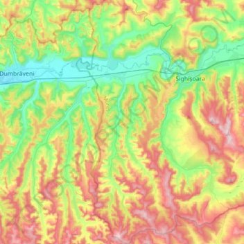
Name: Daneș topographic map, elevation, terrain.
Location: Daneș, Mureș, Romania (46.07635 24.65056 46.28782 24.77650)
Average elevation: 470 m
Minimum elevation: 315 m
Maximum elevation: 695 m
Other topographic maps
Click on a map to view its topography, its elevation and its terrain.
Târgu Mureș
Târgu Mureș, Targu Mures Metropolitan Area, Mureș, Romania
Average elevation: 357 m
Transylvania
Transylvania, Band, Mureș, 547065, Romania
Average elevation: 648 m