
Saint Petersburg topographic map
Interactive map
Click on the map to display elevation.
Saint Petersburg
The elevation of Saint Petersburg ranges from the sea level to its highest point of 175.9 m (577 ft) at the Orekhovaya Hill in the Duderhof Heights in the south. Part of the city's territory west of Liteyny Prospekt is no higher than 4 m (13 ft) above sea level, and has suffered from numerous floods. Floods in Saint Petersburg are triggered by a long wave in the Baltic Sea, caused by meteorological conditions, winds and shallowness of the Neva Bay. The five most disastrous floods occurred in 1824 (4.21 m or 13 ft 10 in above sea level, during which over 300 buildings were destroyed), 1924 (3.8 m, 12 ft 6 in), 1777 (3.21 m, 10 ft 6 in), 1955 (2.93 m, 9 ft 7 in), and 1975 (2.81 m, 9 ft 3 in). To prevent floods, the Saint Petersburg Dam has been constructed.
About this map
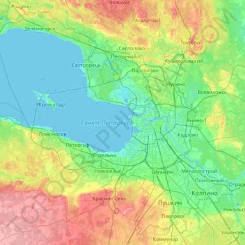
Name: Saint Petersburg topographic map, elevation, terrain.
Location: Saint Petersburg, Northwestern Federal District, Russia (59.63378 29.42576 60.24484 30.75949)
Average elevation: 40 m
Minimum elevation: -7 m
Maximum elevation: 171 m
Other topographic maps
Click on a map to view its topography, its elevation and its terrain.
Sadon
Russia > Republic of North Ossetia – Alania > Alagirsky District > Sadon
Average elevation: 2,161 m
Batagaika crater
Russia > Sakha Republic > Verkhoyansky Ulus
According to a conference paper published in 2016 the crater did not show any signs of stabilization after several decades (since 1980s) of slump growth, with the headwall retreating with observed rates of generally >10 m and up to 30m per year closer to 2016. Reconstruction of a paleo-surface revealed that…
Average elevation: 263 m
The Goat Cape
Russia > Krasnoyarsk Krai > Krasnoyarsk Urban Okrug > Krasnoyarsk
Average elevation: 271 m
Sochi
Russia > Krasnodar Krai > Resort Town of Sochi (municipal formation)
Sochi has a humid subtropical climate (Köppen climate classification Cfa), at the lower elevations. Its average annual temperature is 18.9 °C (66.0 °F) during the day and 11.5 °C (52.7 °F) at night. In the coldest months—January and February—the average temperature is about 10 °C (50 °F) during the…
Average elevation: 148 m
13-й квартал
Russia > Krasnodar Krai > городской округ Горячий Ключ > Saratovskaya
Average elevation: 54 m
Siberia
Russia > Krasnoyarsk Krai > Boguchansky Rayon
Eastern and central Sakha comprises numerous north–south mountain ranges of various ages. These mountains extend up to almost 3,000 metres (9,800 ft), but above a few hundred metres they are almost completely devoid of vegetation. The Verkhoyansk Range was extensively glaciated in the Pleistocene, but the…
Average elevation: 346 m
Ural Mountains
Russia > Khanty-Mansiysk Autonomous Okrug – Ugra > Beryozovsky District
The Ural Mountains (/ˈjʊərəl/ YOOR-əl; Russian: Ура́льские го́ры, tr. Uralskiye gory, IPA: [ʊˈralʲskʲɪjə ˈɡorɨ]; Bashkir: Урал тауҙары) or simply the Urals, are a mountain range in Eurasia that runs north-south mostly through Russia, from the coast of the Arctic Ocean to…
Average elevation: 1,435 m
Khanty-Mansiysk
Russia > Khanty-Mansiysk Autonomous Okrug – Ugra > Khanty-Mansiysk Urban Okrug > Khanty-Mansiysk
Average elevation: 29 m