Geolocate

Central Hawke's Bay District topographic map

Interactive map

Click on the map to display elevation.

About this map

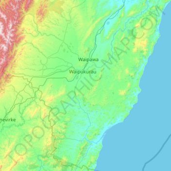
Name: Central Hawke's Bay District topographic map, elevation, terrain.

Location: Central Hawke's Bay District, Hawke's Bay, New Zealand (-40.43129 176.09383 -39.68006 176.96769)

Average elevation: 236 m

Minimum elevation: -1 m

Maximum elevation: 1,718 m

Other topographic maps

Click on a map to view its topography, its elevation and its terrain.

Sherenden

New Zealand > Hawke's Bay > Hastings District

Sherenden, Hastings District, Hawke's Bay, New Zealand

Average elevation: 258 m

Waipukurau

New Zealand > Hawke's Bay > Central Hawke's Bay District

Waipukurau, Central Hawke's Bay District, Hawke's Bay, 4200, New Zealand

Average elevation: 153 m

Hastings District

New Zealand > Hawke's Bay

Hastings District, Hawke's Bay, New Zealand

Average elevation: 466 m

Hastings

New Zealand > Hawke's Bay > Hastings District

Hastings, Hastings District, Hawke's Bay, 4122, New Zealand

Average elevation: 68 m

Te Awanga

New Zealand > Hawke's Bay > Hastings District

Te Awanga, Hastings District, Hawke's Bay, 4180, New Zealand

Average elevation: 22 m

Cape Kidnappers / Te Kauwae-a-Māui

New Zealand > Hawke's Bay > Hastings District

Cape Kidnappers / Te Kauwae-a-Māui, Hastings District, Hawke's Bay, New Zealand

Average elevation: 16 m

Pakipaki

New Zealand > Hawke's Bay > Hastings District > Hastings

Pakipaki, Hastings, Hastings District, Hawke's Bay, 4178, New Zealand

Average elevation: 61 m

Napier

New Zealand > Hawke's Bay

Napier, Hawke's Bay, New Zealand

Average elevation: 12 m