
Baruan topographic map
Interactive map
Click on the map to display elevation.
About this map
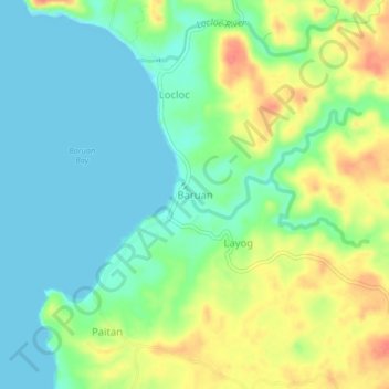
Name: Baruan topographic map, elevation, terrain.
Location: Baruan, Pangasinan, Ilocos Region, 2410, Philippines (16.00197 119.75605 16.04197 119.79605)
Average elevation: 24 m
Minimum elevation: -1 m
Maximum elevation: 68 m
Other topographic maps
Click on a map to view its topography, its elevation and its terrain.
San Fabian
San Fabian, Pangasinan, Ilocos Region, 2433, Philippines
Average elevation: 5 m
San Gabriel 2nd
San Gabriel 2nd, Pangasinan, Ilocos Region, 2423, Philippines
Average elevation: 15 m
San Angel
San Angel, Pangasinan, Ilocos Region, Philippines
Average elevation: 39 m
Laoac
Laoac, Pangasinan, Ilocos Region, 2436, Philippines
Average elevation: 30 m
Bayambang
Philippines > Pangasinan > Bayambang
Bayambang, Pangasinan, Ilocos Region, 2423, Philippines
Average elevation: 17 m
Cabuyao
Philippines > Pangasinan > Cabuyao
Cabuyao, Bolinao, Pangasinan, Ilocos Region, 2406, Philippines
Average elevation: 48 m