
Grand Park topographic map
Interactive map
Click on the map to display elevation.
About this map
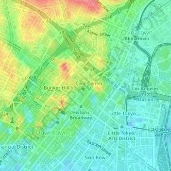
Name: Grand Park topographic map, elevation, terrain.
Average elevation: 103 m
Minimum elevation: 76 m
Maximum elevation: 155 m
Other topographic maps
Click on a map to view its topography, its elevation and its terrain.
Downtown
United States > California > Los Angeles County > Los Angeles
Downtown, Los Angeles, Los Angeles County, California, United States
Average elevation: 84 m
Venice Beach
United States > California > Los Angeles County > Los Angeles
Venice Beach, Venice, Los Angeles, Los Angeles County, California, United States
Average elevation: 4 m
San Fernando Valley
United States > California > Los Angeles County > Los Angeles
San Fernando Valley, Los Angeles, Los Angeles County, CAL Fire Contract Counties, California, 91406, United States
Average elevation: 496 m
Thenard
United States > California > Los Angeles County > Los Angeles
Thenard, Los Angeles, Los Angeles County, CAL Fire Contract Counties, California, 90810, United States
Average elevation: 8 m
Griffith Park
United States > California > Los Angeles County > Los Angeles
Griffith Park, Los Angeles, Los Angeles County, CAL Fire Southern Region, California, United States
Average elevation: 221 m
Exposition Park
United States > California > Los Angeles County > Los Angeles
Exposition Park, Los Angeles, Los Angeles County, CAL Fire Southern Region, California, United States
Average elevation: 55 m
Hollywood Hills
United States > California > Los Angeles County > Los Angeles
Hollywood Hills, Los Angeles, Los Angeles County, California, 90068, United States
Average elevation: 242 m
Pacific Palisades
United States > California > Los Angeles County > Los Angeles
Pacific Palisades, Los Angeles, Los Angeles County, California, United States
Average elevation: 196 m
Harbor City
United States > California > Los Angeles County > Los Angeles > Harbor Pines
Harbor City, Harbor Pines, Los Angeles, Los Angeles County, CAL Fire Contract Counties, California, 90717, United States
Average elevation: 45 m
Van Nuys
United States > California > Los Angeles County > Los Angeles
Van Nuys, Los Angeles, Los Angeles County, California, United States
Average elevation: 228 m
Rio de Los Angeles State Park State Recreational Area
United States > California > Los Angeles County > Los Angeles
Rio de Los Angeles State Park State Recreational Area, Lincoln Heights, Los Angeles, Los Angeles County, CAL Fire Contract Counties, California, United States
Average elevation: 141 m