
Bulgan topographic map
Interactive map
Click on the map to display elevation.
About this map
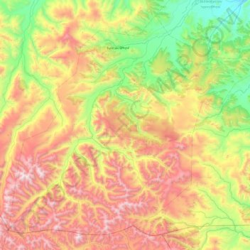
Name: Bulgan topographic map, elevation, terrain.
Location: Bulgan, Archangai, Mongolei (46.82467 100.69534 47.40225 101.65964)
Average elevation: 2,367 m
Minimum elevation: 1,631 m
Maximum elevation: 3,470 m
Other topographic maps
Click on a map to view its topography, its elevation and its terrain.
Чулуут ᠴᠢᠯᠠᠭᠤᠲᠤ
Mongolei > Archangai > Chuluut
Чулуут ᠴᠢᠯᠠᠭᠤᠲᠤ, Chuluut, Archangai, Mongolei
Average elevation: 2,096 m
Tsetserleg
Mongolei > Archangai > Erdenebulgan > Tsetserleg
Tsetserleg, Erdenebulgan, Archangai, -0976, Mongolei
Average elevation: 1,813 m
Тэрхийн Цагаан нуур
Тэрхийн Цагаан нуур, Tariat-Jargalant, Tariat, Archangai, Mongolei
Average elevation: 2,163 m