
Mount Tabor topographic map
Interactive map
Click on the map to display elevation.
About this map
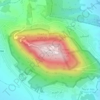
Name: Mount Tabor topographic map, elevation, terrain.
Location: Mount Tabor, Jezreel Subdistrict, North District, Israel (32.68706 35.38957 32.68716 35.38967)
Average elevation: 250 m
Minimum elevation: 101 m
Maximum elevation: 561 m
Other topographic maps
Click on a map to view its topography, its elevation and its terrain.
Kfar Vradim
Kfar Vradim, Acre Subdistrict, North District, Israel
Average elevation: 566 m
Kinneret Moshava
Israel > North District > Emek HaYarden Regional Council
Kinneret Moshava, Emek HaYarden Regional Council, Kinneret Subdistrict, North District, Israel
Average elevation: -134 m
Atsmon-Segev
Israel > North District > Misgav Regional Council
Atsmon-Segev, Misgav Regional Council, Acre Subdistrict, North District, Israel
Average elevation: 256 m
Arraba
Arraba, Acre Subdistrict, North District, Israel
Average elevation: 257 m
Tel Megiddo National Park
Israel > North District > Megido Regional Council > Megiddo
Tel Megiddo National Park, 6951, Megiddo, Megido Regional Council, Jezreel Subdistrict, North District, Israel
Average elevation: 129 m
Mate Asher Regional Council
Israel > North District > Mate Asher Regional Council
Mate Asher Regional Council, Acre Subdistrict, North District, 22845, Israel
Average elevation: 185 m
Nahariyya
Israel > North District > Nahariya
Nahariyya, Nahariya, Acre Subdistrict, North District, Israel
Average elevation: 14 m
1204 Mount Meron
Israel > North District > Merom HaGalil Regional Council
1204 Mount Meron, Merom HaGalil Regional Council, Safed Subdistrict, North District, Israel
Average elevation: 943 m