
ہجیرہ topographic map
Interactive map
Click on the map to display elevation.
About this map
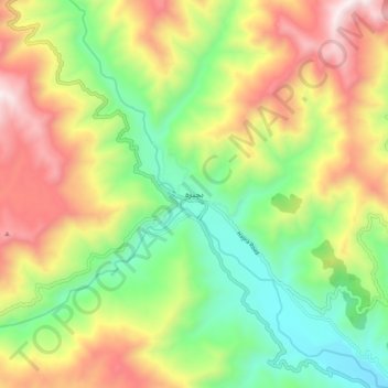
Name: ہجیرہ topographic map, elevation, terrain.
Location: ہجیرہ, ضلع پونچھ, Azad Cachemire, Pakistan (33.73155 73.85679 33.81155 73.93679)
Average elevation: 1,287 m
Minimum elevation: 811 m
Maximum elevation: 1,930 m
Other topographic maps
Click on a map to view its topography, its elevation and its terrain.
Muzaffarabad
Muzaffarabad, ضلع مظفر آباد, Azad Cachemire, 13100, Pakistan
Average elevation: 1,530 m
taho
Pakistan > Azad Cachemire > taho
taho, ضلع بھمبر, Azad Cachemire, Pakistan
Average elevation: 282 m
Keran
Pakistan > Azad Cachemire > Keran
Keran, ضلع وادیِ نیلم, Azad Cachemire, Pakistan
Average elevation: 1,880 m
Kangra
Pakistan > Azad Cachemire > Kangra
Kangra, ضلع میرپور, Azad Cachemire, 10250, Pakistan
Average elevation: 278 m