
Xichang City topographic map
Interactive map
Click on the map to display elevation.
Xichang City
Owing to its low latitude and high elevation, Xichang has a monsoon-influenced humid subtropical climate (Köppen Cwa) milder and far sunnier than the Sichuan Basin, with mild, very sunny and dry winters, and very warm, rainy summers. The monthly 24-hour average temperature ranges from 9.9 °C (49.8 °F) in January to 22.6 °C (72.7 °F) in July, and the annual mean is 17.15 °C (62.9 °F). Over 60% of the 1,025 mm (40.4 in) annual precipitation occurs from June to August. With monthly percent possible sunshine ranging from 36% in September to 72% in January, the city receives 2,367 hours of bright sunshine annually.
About this map
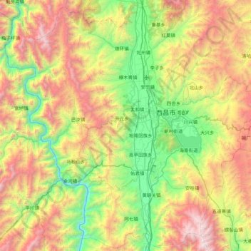
Name: Xichang City topographic map, elevation, terrain.
Location: Xichang City, Liangshan, Sichuan, 615000, China (27.54469 101.76800 28.18094 102.50767)
Average elevation: 2,319 m
Minimum elevation: 1,185 m
Maximum elevation: 4,195 m
Other topographic maps
Click on a map to view its topography, its elevation and its terrain.
Mount Gongga
China > Sichuan > Luding County
Mount Gongga (simplified Chinese: 贡嘎山; traditional Chinese: 貢嘎山; pinyin: Gònggá Shān), also known as Minya Konka (Khams Tibetan pinyin: Mi'nyâg Gong'ga Riwo) and colloquially as "The King of Sichuan Mountains", is the highest mountain in Sichuan province, China. It has an elevation of 7,556 m…
Average elevation: 6,496 m
Tagong
It is the location of Lha'ggong Monastery — a gompa and one of the most important in the area, in Tibetan Pel Lhagong. It was established with reference to a nearby sacred mountain, Mt. Yala or Zhara Lhaste, 5,820 metres (19,090 ft) in elevation.
Average elevation: 3,874 m
Xichang
Owing to its low latitude and high elevation, Xichang has a monsoon-influenced humid subtropical climate (Köppen Cwa) milder and far sunnier than the Sichuan Basin, with mild, very sunny and dry winters, and very warm, rainy summers. The monthly 24-hour average temperature ranges from 9.9 °C (49.8 °F) in…
Average elevation: 1,970 m