
Sugar Bag Road Town Reserve topographic map
Interactive map
Click on the map to display elevation.
About this map
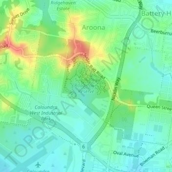
Name: Sugar Bag Road Town Reserve topographic map, elevation, terrain.
Average elevation: 19 m
Minimum elevation: 0 m
Maximum elevation: 57 m
Other topographic maps
Click on a map to view its topography, its elevation and its terrain.
Buderim
Australia > Queensland > Sunshine Coast Regional
Buderim, Sunshine Coast Regional, Queensland, 4556, Australia
Average elevation: 32 m
Sunshine Coast
Australia > Queensland > Sunshine Coast Regional
Sunshine Coast, Sunshine Coast Regional, Queensland, Australia
Average elevation: 109 m
Caloundra
Australia > Queensland > Sunshine Coast Regional
Caloundra, Sunshine Coast Regional, Queensland, 4551, Australia
Average elevation: 5 m
Kondalilla Falls Lookout
Australia > Queensland > Sunshine Coast Regional
Kondalilla Falls Lookout, Picnic Creek Circuit, Montville, Sunshine Coast Regional, Queensland, Australia
Average elevation: 340 m
Wootha
Australia > Queensland > Sunshine Coast Regional
Wootha, Sunshine Coast Regional, Queensland, Australia
Average elevation: 396 m
Bald Knob
Australia > Queensland > Sunshine Coast Regional
Bald Knob, Sunshine Coast Regional, Queensland, Australia
Average elevation: 245 m
Conondale State Forest
Australia > Queensland > Sunshine Coast Regional
Conondale State Forest, Kenilworth, Sunshine Coast Regional, Queensland, Australia
Average elevation: 271 m
Mount Mellum
Australia > Queensland > Sunshine Coast Regional
Mount Mellum, Sunshine Coast Regional, Queensland, Australia
Average elevation: 163 m
Woorim Park
Australia > Queensland > Sunshine Coast Regional
Woorim Park, Golden Beach, Sunshine Coast Regional, Queensland, Australia
Average elevation: 1 m
Burnside
Australia > Queensland > Sunshine Coast Regional
Burnside, Sunshine Coast Regional, Queensland, Australia
Average elevation: 63 m
Mons
Australia > Queensland > Sunshine Coast Regional
Mons, Sunshine Coast Regional, Queensland, 4556, Australia
Average elevation: 75 m
North Maleny
Australia > Queensland > Sunshine Coast Regional
North Maleny, Sunshine Coast Regional, Queensland, Australia
Average elevation: 326 m
Coochin Creek
Australia > Queensland > Sunshine Coast Regional
Coochin Creek, Sunshine Coast Regional, Queensland, Australia
Average elevation: 7 m
Elaman Creek
Australia > Queensland > Sunshine Coast Regional
Elaman Creek, Sunshine Coast Regional, Queensland, Australia
Average elevation: 250 m
Coolabine
Australia > Queensland > Sunshine Coast Regional
Coolabine, Sunshine Coast Regional, Queensland, Australia
Average elevation: 198 m
Kidaman Creek
Australia > Queensland > Sunshine Coast Regional
Kidaman Creek, Sunshine Coast Regional, Queensland, Australia
Average elevation: 230 m
Coes Creek
Australia > Queensland > Sunshine Coast Regional
Coes Creek, Sunshine Coast Regional, Queensland, Australia
Average elevation: 41 m
Little Mountain
Australia > Queensland > Sunshine Coast Regional
Little Mountain, Sunshine Coast Regional, Queensland, 4551, Australia
Average elevation: 16 m
Aroona
Australia > Queensland > Sunshine Coast Regional
Aroona, Sunshine Coast Regional, Queensland, Australia
Average elevation: 19 m
Maroochydore
Australia > Queensland > Sunshine Coast Regional
Maroochydore, Sunshine Coast Regional, Queensland, 4558, Australia
Average elevation: 6 m
Alexandra Headland
Australia > Queensland > Sunshine Coast Regional
Alexandra Headland, Sunshine Coast Regional, Queensland, 4572, Australia
Average elevation: 10 m
Cooloolabin
Australia > Queensland > Sunshine Coast Regional
Cooloolabin, Sunshine Coast Regional, Queensland, Australia
Average elevation: 197 m
Yandina Creek
Australia > Queensland > Sunshine Coast Regional
Yandina Creek, Sunshine Coast Regional, Queensland, Australia
Average elevation: 25 m
Kiels Mountain
Australia > Queensland > Sunshine Coast Regional
Kiels Mountain, Sunshine Coast Regional, Queensland, Australia
Average elevation: 31 m
Maleny
Australia > Queensland > Sunshine Coast Regional
Maleny, Sunshine Coast Regional, Queensland, Australia
Average elevation: 389 m
Banya
Australia > Queensland > Sunshine Coast Regional
Banya, Sunshine Coast Regional, Queensland, Australia
Average elevation: 14 m
Dulong
Australia > Queensland > Sunshine Coast Regional
Dulong, Sunshine Coast Regional, Queensland, Australia
Average elevation: 254 m
Golden Beach
Australia > Queensland > Sunshine Coast Regional
Golden Beach, Sunshine Coast Regional, Queensland, Australia
Average elevation: 2 m
Towen Mountain
Australia > Queensland > Sunshine Coast Regional
Towen Mountain, Sunshine Coast Regional, Queensland, Australia
Average elevation: 113 m
Kulangoor
Australia > Queensland > Sunshine Coast Regional
Kulangoor, Sunshine Coast Regional, Queensland, Australia
Average elevation: 59 m
Nambour
Australia > Queensland > Sunshine Coast Regional
Nambour, Sunshine Coast Regional, Queensland, 4560, Australia
Average elevation: 41 m
Woombye
Australia > Queensland > Sunshine Coast Regional
Woombye, Sunshine Coast Regional, Queensland, 4559, Australia
Average elevation: 32 m
Chevallum
Australia > Queensland > Sunshine Coast Regional
Chevallum, Sunshine Coast Regional, Queensland, Australia
Average elevation: 33 m
Crohamhurst
Australia > Queensland > Sunshine Coast Regional
Crohamhurst, Sunshine Coast Regional, Queensland, Australia
Average elevation: 198 m
Ninderry
Australia > Queensland > Sunshine Coast Regional
Ninderry, Sunshine Coast Regional, Queensland, Australia
Average elevation: 54 m
Bokarina
Australia > Queensland > Sunshine Coast Regional
Bokarina, Sunshine Coast Regional, Queensland, Australia
Average elevation: 2 m
Peachester
Australia > Queensland > Sunshine Coast Regional
Peachester, Sunshine Coast Regional, Queensland, Australia
Average elevation: 163 m
Baringa
Australia > Queensland > Sunshine Coast Regional
Baringa, Sunshine Coast Regional, Queensland, Australia
Average elevation: 6 m
Rosemount
Australia > Queensland > Sunshine Coast Regional
Rosemount, Sunshine Coast Regional, Queensland, Australia
Average elevation: 28 m
Image Flat
Australia > Queensland > Sunshine Coast Regional
Image Flat, Sunshine Coast Regional, Queensland, Australia
Average elevation: 130 m
Pelican Waters
Australia > Queensland > Sunshine Coast Regional
Pelican Waters, Sunshine Coast Regional, Queensland, Australia
Average elevation: 3 m
Landers Shoot
Australia > Queensland > Sunshine Coast Regional
Landers Shoot, Sunshine Coast Regional, Queensland, Australia
Average elevation: 88 m
Marcoola
Australia > Queensland > Sunshine Coast Regional
Marcoola, Sunshine Coast Regional, Queensland, Australia
Average elevation: 2 m
Sippy Downs
Australia > Queensland > Sunshine Coast Regional
Sippy Downs, Sunshine Coast Regional, Queensland, Australia
Average elevation: 12 m
Eudlo
Australia > Queensland > Sunshine Coast Regional
Eudlo, Sunshine Coast Regional, Queensland, Australia
Average elevation: 90 m
Mooloolaba
Australia > Queensland > Sunshine Coast Regional
Mooloolaba, Sunshine Coast Regional, Queensland, Australia
Average elevation: 7 m
Kiamba
Australia > Queensland > Sunshine Coast Regional
Kiamba, Sunshine Coast Regional, Queensland, Australia
Average elevation: 148 m
West Woombye
Australia > Queensland > Sunshine Coast Regional
West Woombye, Sunshine Coast Regional, Queensland, Australia
Average elevation: 87 m
Forest Glen
Australia > Queensland > Sunshine Coast Regional
Forest Glen, Sunshine Coast Regional, Queensland, Australia
Average elevation: 30 m
Battery Hill
Australia > Queensland > Sunshine Coast Regional
Battery Hill, Sunshine Coast Regional, Queensland, Australia
Average elevation: 10 m