
Royal National Park topographic map
Interactive map
Click on the map to display elevation.
About this map
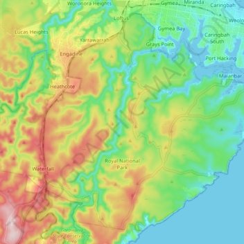
Name: Royal National Park topographic map, elevation, terrain.
Average elevation: 106 m
Minimum elevation: -3 m
Maximum elevation: 308 m
New South Wales trails, hiking, mountain biking, running and outdoor activities
Other topographic maps
Click on a map to view its topography, its elevation and its terrain.
Mount Kosciuszko
Mount Kosciuszko is the highest summit in mainland Australia. Until 1977 it was possible to drive from Charlotte Pass to within a few metres of the summit, but in 1977 the road was closed to public motor vehicle access due to environmental concerns. The road is open from Charlotte Pass for walkers and cyclists…
Average elevation: 2,035 m
Sydney
Phillip had been given no instructions for urban development, but in July 1788 submitted a plan for the new town at Sydney Cove. It included a wide central avenue, a permanent Government House, law courts, hospital and other public buildings, but no provision for warehouses, shops, or other commercial…
Average elevation: 32 m
Blue Mountains
A sandstone plateau dominated by a landscape of endless eucalyptus forests, the Blue Mountains are located at the top of a 470-million-year-old quartzite. In the Permian period, a shallow sea covered the region, when rivers brought shales, siltstones and mudstones. Then during the Mesozoic period, rivers…
Average elevation: 566 m
Mount Kosciuszko
Mount Kosciuszko (/ˌkɒziˈʌskoʊ/ KOZ-ee-USK-oh; Polish pronunciation: [kɔɕˈt͡ɕuʂ.kɔ] kosh-CHOOSH-koh; Ngarigo: Kunama Namadgi) is the highest mountain of the mainland Australia, at 2,228 metres (7,310 ft) above sea level. It is located on the Main Range of the Snowy Mountains in Kosciuszko National…
Average elevation: 2,035 m
Woronora Dam
The wall of Woronora Dam is an engineering work imbued with a sense of high aesthetic value expressed through the long curved high wall set with the wide valley of the Woronora River. Upstream of the dam wall this setting is characterised by the broad expanse of the pool of water bordered by the crests of the…
Average elevation: 198 m