
Sint Eustatius topographic map
Interactive map
Click on the map to display elevation.
About this map
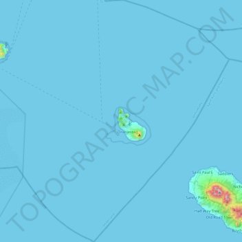
Name: Sint Eustatius topographic map, elevation, terrain.
Location: Sint Eustatius, Netherlands (17.27673 -63.19861 17.72699 -62.78471)
Average elevation: 12 m
Minimum elevation: 0 m
Maximum elevation: 1,044 m
Sint Eustatius is 6 miles (10 km) long and up to 3 miles (5 km) wide. Topographically, the island is saddle-shaped, with the 602-meter-high dormant volcano Quill (Mount Mazinga), (from Dutch kuil, meaning 'pit'—originally referring to its crater) to the southeast and the smaller summits of Signal Hill/Little Mountain (or Bergje) and Boven Mountain to the northwest. The Quill crater is a popular tourist attraction on the island. The bulk of the island's population lives in the flat saddle between the two elevated areas, which forms the centre of the island.
Other topographic maps
Click on a map to view its topography, its elevation and its terrain.
Oud-Loosdrecht
Netherlands > North Holland > Loosdrecht
Oud-Loosdrecht, Loosdrecht, Wijdemeren, North Holland, Netherlands, 1231 LV, Netherlands
Average elevation: -1 m
Noordoostpolder
Noordoostpolder, Flevoland, Netherlands
Average elevation: -1 m
Boskoop
Boskoop, Alphen aan den Rijn, South Holland, Netherlands
Average elevation: -2 m
Eiland van Bèr
Netherlands > Limburg > Maastricht
Eiland van Bèr, Maastricht, Limburg, Netherlands, 6212 NE, Netherlands
Average elevation: 137 m
Gorinchem
Netherlands > South Holland > Gorinchem
Gorinchem, South Holland, Netherlands
Average elevation: 1 m
Spijkenisse
Spijkenisse, Nissewaard, South Holland, Netherlands
Average elevation: 1 m
Twente
Netherlands > Overijssel > Saasveld
Twente, Saasveld, Dinkelland, Overijssel, Netherlands, 7597 KL, Netherlands
Average elevation: 36 m
Zeewolde
Netherlands > Flevoland > Zeewolde
Zeewolde, Flevoland, Netherlands, Zeewolde
Average elevation: -2 m
Warmenhuizen
Warmenhuizen, Schagen, North Holland, Netherlands
Average elevation: 0 m
Badhoevedorp
Badhoevedorp, Haarlemmermeer, North Holland, Netherlands
Average elevation: -2 m
Zwarte Water
Netherlands > Overijssel > Zwolle
Zwarte Water, Binnenstad, Zwolle, Overijssel, Netherlands, 8031 ES, Netherlands
Average elevation: 4 m
Purmerend
Netherlands > North Holland > Purmerend
Purmerend, North Holland, Netherlands
Average elevation: -2 m
's-Hertogenbosch
Netherlands > North Brabant > 's-Hertogenbosch
's-Hertogenbosch, North Brabant, Netherlands
Average elevation: 4 m
Amsterdam
Netherlands > North Holland > Amsterdam
Amsterdam, North Holland, Netherlands, 1012JS, Netherlands
Average elevation: -1 m
Vlaardingen
Netherlands > South Holland > Vlaardingen
Vlaardingen, South Holland, Netherlands
Average elevation: 1 m
Hoogvliet Rotterdam
Netherlands > South Holland > Hoogvliet Rotterdam
Hoogvliet Rotterdam, Rotterdam, South Holland, Netherlands
Average elevation: 2 m
Drunen
Netherlands > North Brabant > Drunen
Drunen, Heusden, North Brabant, Netherlands
Average elevation: 6 m
Hoofddorp
Netherlands > North Holland > Hoofddorp
Hoofddorp, Haarlemmermeer, North Holland, Netherlands
Average elevation: -3 m
Udenhout
Netherlands > North Brabant > Udenhout
Udenhout, Tilburg, North Brabant, Netherlands
Average elevation: 10 m
Haarlem
Netherlands > North Holland > Haarlem
Haarlem, North Holland, Netherlands
Average elevation: 3 m
Leeward Islands
Leeward Islands, Zion's Hill, Saba, Netherlands
Average elevation: 112 m
Capelle aan den IJssel
Capelle aan den IJssel, South Holland, Netherlands
Average elevation: -1 m
Veldhoven
Netherlands > North Brabant > Veldhoven
Veldhoven, North Brabant, Netherlands
Average elevation: 23 m