Geolocate

Waitui Stream topographic map

Interactive map

Click on the map to display elevation.

About this map

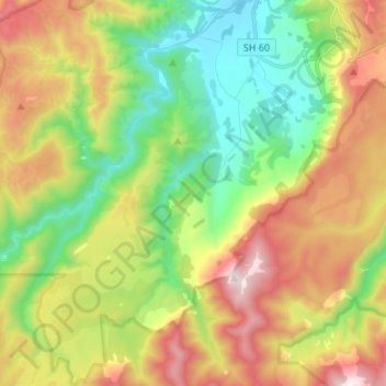
Name: Waitui Stream topographic map, elevation, terrain.

Location: Waitui Stream, Tasman, New Zealand (-41.12005 172.78852 -41.01891 172.81909)

Average elevation: 561 m

Minimum elevation: 84 m

Maximum elevation: 1,263 m

Other topographic maps

Click on a map to view its topography, its elevation and its terrain.

Tākaka

New Zealand > Tasman

Average elevation: 50 m

Kaituna River

New Zealand > Tasman > Tasman District

Average elevation: 263 m

Battery Hill

New Zealand > Tasman

Average elevation: 180 m

Golden Bay

New Zealand > Tasman > Tasman District

Average elevation: 43 m

Wakefield

New Zealand > Tasman > Wakefield

Average elevation: 134 m

Abel Tasman National Park

New Zealand > Tasman

Average elevation: 271 m

Ngatimoti

New Zealand > Tasman > Ngatimoti

Average elevation: 103 m

Glenhope

New Zealand > Tasman > Glenhope

Average elevation: 537 m

Clifton

New Zealand > Tasman > Pohara > Clifton

Average elevation: 68 m

Richmond

New Zealand > Tasman > Richmond

Average elevation: 83 m