
Guangdong Province topographic map
Interactive map
Click on the map to display elevation.
About this map
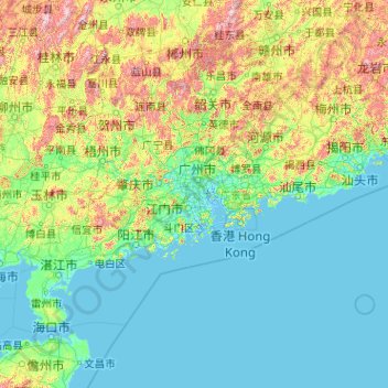
Name: Guangdong Province topographic map, elevation, terrain.
Location: Guangdong Province, China (20.11981 109.44948 25.51952 117.58023)
Average elevation: 194 m
Minimum elevation: -5 m
Maximum elevation: 1,988 m
Guangdong faces the South China Sea to the south and has a total of 4,300 km (2,700 mi) of coastline. The Leizhou Peninsula is on the southwestern end of the province. There are a few inactive volcanoes on Leizhou Peninsula. The Pearl River Delta is the convergent point of three upstream rivers: the East River, North River, and West River. The river delta is filled with hundreds of small islands. The province is geographically separated from the north by a few mountain ranges collectively called the Nan Mountains (Nan Ling). The highest peak in the province is Shikengkong with an elevation of 6,240 feet (1,902 meters) above sea level.
Other topographic maps
Click on a map to view its topography, its elevation and its terrain.
Hezuo
China > Gansu > Hezuo City
Hezuo, Hezuo City, Gannan, Gansu, 747000, China
Average elevation: 3,199 m
Nuozhadu Dam
China > Yunnan > Lancang Lahu Autonomous County
Nuozhadu Dam, Lancang Lahu Autonomous County, Pu'er City, Yunnan, China
Average elevation: 843 m
Qanag
China > Tibet > Mainling City
Qanag, Mainling City, Nyingchi Prefecture, Tibet, China
Average elevation: 3,790 m
Xin'anjiang Hydropower Station
China > Zhejiang > Jiande > 滩头坞
Xin'anjiang Hydropower Station, 滩头坞, Jiande, Zhejiang, China
Average elevation: 158 m
Tarim Basin
China > Xinjiang > Qarqan County > Tazhong Town
Tarim Basin, Tazhong Town, Qarqan County, Bayingolin, Xinjiang, China
Average elevation: 1,055 m
Yellow River
China > Gansu > Maqu County > Gaoyuan Institute of Biology
Yellow River, Gaoyuan Institute of Biology, Maqu County, Gannan, Gansu, China
Average elevation: 3,505 m
Taiping District
Taiping District, Fuxin City, Liaoning, 123000, China
Average elevation: 235 m
Xi'nanci
China > Beijing > Daxing District
Xi'nanci, Daxing District, Beijing, China
Average elevation: 34 m
Yangtougang
China > Beijing > Fangshan District
Yangtougang, Fangshan District, Beijing, 102400, China
Average elevation: 61 m
Dali Bai Autonomous Prefecture
Dali Bai Autonomous Prefecture, Yunnan, China
Average elevation: 2,168 m
Heihe
China > Heilongjiang > 幸福乡
Heihe, 幸福乡, Aihui District, Heihe City, Heilongjiang, 164300, China
Average elevation: 174 m
Tianshan District
Tianshan District, Ürümqi, Xinjiang, 830000, China
Average elevation: 1,108 m
Bangshan
China > Fujian > Longhai District
Bangshan, Longhai District, Zhangzhou City, Fujian, China
Average elevation: 37 m
Haixi Mongol and Tibetan Autonomous Prefecture
Haixi Mongol and Tibetan Autonomous Prefecture, Qinghai, China
Average elevation: 3,739 m
Zhongshan
China > Guangxi > Zhongshan County
Zhongshan, Zhongshan County, Hezhou, Guangxi, China
Average elevation: 246 m