
Greater Accra Region topographic map
Interactive map
Click on the map to display elevation.
About this map
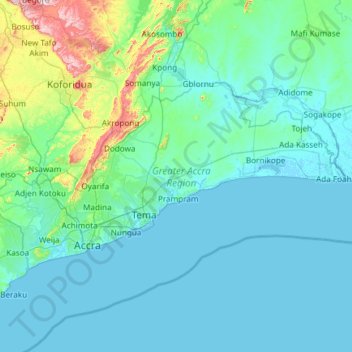
Name: Greater Accra Region topographic map, elevation, terrain.
Location: Greater Accra Region, Ghana (5.47065 -0.51970 6.10761 0.67226)
Average elevation: 62 m
Minimum elevation: -5 m
Maximum elevation: 665 m
Other topographic maps
Click on a map to view its topography, its elevation and its terrain.
Kumasi
Ghana > Ashanti Region > Kumasi Metropolitan District
Kumasi, Kumasi Metropolitan District, Ashanti Region, Ghana
Average elevation: 256 m
Atua
Ghana > Western North Region > Aowin Municipal District > Enchi
Atua, Zongo, Enchi, Aowin Municipal District, Western North Region, Ghana
Average elevation: 88 m
Kaneshie
Ghana > Greater Accra Region > Accra Metropolitan District > Accra
Kaneshie, Accra, Accra Metropolitan District, Greater Accra Region, GA-254-4987, Ghana
Average elevation: 24 m
Accra
Ghana > Greater Accra Region > Korle-Klottey Municipal District
Accra, Korle-Klottey Municipal District, Greater Accra Region, Ghana
Average elevation: 31 m
Pwalugu
Pwalugu, Talensi District, Upper East Region, Ghana
Average elevation: 161 m
Asankrangwa
Ghana > Western Region > Amenfi West Municipal District
Asankrangwa, Amenfi West Municipal District, Western Region, Ghana
Average elevation: 107 m
Kassena-Nankana West District
Kassena-Nankana West District, Upper East Region, Ghana
Average elevation: 233 m
Bolgatanga
Ghana > Upper East Region > Bolgatanga
Bolgatanga, Upper East Region, Ghana
Average elevation: 188 m
Shama
Ghana > Western Region > Shama District
Shama, Shama District, Western Region, Ghana
Average elevation: 8 m
Takoradi
Ghana > Western Region > Takoradi
Takoradi, Western Region, MC 1613, Ghana
Average elevation: 13 m
West Gonja
Ghana > Savannah Region > West Gonja
West Gonja, Savannah Region, Ghana
Average elevation: 162 m