
Liangshan topographic map
Interactive map
Click on the map to display elevation.
About this map
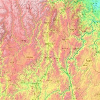
Name: Liangshan topographic map, elevation, terrain.
Location: Liangshan, Sichuan, China (26.04817 100.16675 29.30510 103.87517)
Average elevation: 2,439 m
Minimum elevation: 312 m
Maximum elevation: 5,740 m
Owing to its low latitude and high elevation, Liangshan has a mild climate. Under the Köppen system, the prefecture belongs to the humid subtropical zone (Köppen Cwa). Winters feature mild days and cool nights, while summers are very warm and humid. Monthly daily mean temperatures range from 9.6 °C (49.3 °F) in January to 22.3 °C (72.1 °F) in July. Unlike much of the province, which lies in the Sichuan Basin, humidity levels in winter are rather low, but like the rest of the province, rainfall is concentrated in the months of June through September, and the prefecture is virtually rainless in winter.
Other topographic maps
Click on a map to view its topography, its elevation and its terrain.
Xichang City
Xichang City, Liangshan, Sichuan, 615000, China
Average elevation: 2,319 m
Mount Gongga
China > Sichuan > Luding County
Mount Gongga, Luding County, Kardze Tibetan Autonomous Prefecture, Sichuan, China
Average elevation: 6,496 m
Mengzhuiwan
China > Sichuan > Chenghua District > Mengzhuiwan
Mengzhuiwan, Chenghua District, Chengdu City, Sichuan, 610054, China
Average elevation: 502 m