Geolocate

Applecross topographic map

Interactive map

Click on the map to display elevation.

About this map

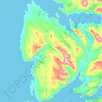
Name: Applecross topographic map, elevation, terrain.

Location: Applecross, Highland, Scotland, United Kingdom (57.34629 -5.87305 57.58604 -5.59579)

Average elevation: 149 m

Minimum elevation: 0 m

Maximum elevation: 904 m

Other topographic maps

Click on a map to view its topography, its elevation and its terrain.

Wick

United Kingdom > Scotland > Highland

Average elevation: 20 m

Inverie

United Kingdom > Scotland > Highland

Average elevation: 147 m

Glackmore

United Kingdom > Scotland > Highland > Inverness

Average elevation: 75 m

Strathnairn

United Kingdom > Scotland > Highland > Daviot

Average elevation: 268 m

Dingwall

United Kingdom > Scotland > Highland

Average elevation: 94 m

Teangue

United Kingdom > Scotland > Highland

Average elevation: 81 m

Kilmore

United Kingdom > Scotland > Highland > Ferindonald

Average elevation: 61 m

Newton of Kinkell

United Kingdom > Scotland > Highland > Mulbuie

Average elevation: 112 m

Whitebridge

United Kingdom > Scotland > Highland

Average elevation: 223 m

Insh

United Kingdom > Scotland > Highland

Average elevation: 275 m

Durness

United Kingdom > Scotland > Highland

Average elevation: 28 m

Eyre

United Kingdom > Scotland > Highland

Average elevation: 72 m

Castletown

United Kingdom > Scotland > Highland

Average elevation: 25 m

Broadford

United Kingdom > Scotland > Highland

Average elevation: 34 m

Glenmore

United Kingdom > Scotland > Highland

Average elevation: 414 m

Aviemore

United Kingdom > Scotland > Highland

Average elevation: 331 m

Ardross

United Kingdom > Scotland > Highland

Average elevation: 223 m

Dalmore

United Kingdom > Scotland > Highland

Average elevation: 118 m

Glenelg

United Kingdom > Scotland > Highland

Average elevation: 78 m

Dundonnell

United Kingdom > Scotland > Highland

Average elevation: 196 m

Gairloch

United Kingdom > Scotland > Highland > Gairloch

Average elevation: 74 m

Scottish Highlands

United Kingdom > Scotland > Highland

The entire region was covered by ice sheets during the Pleistocene ice ages, save perhaps for a few nunataks. The complex geomorphology includes incised valleys and lochs carved by the action of mountain streams and ice, and a topography of irregularly distributed mountains whose summits have similar heights…

Average elevation: 907 m

Ullapool

United Kingdom > Scotland > Highland

Average elevation: 150 m

Thrumster

United Kingdom > Scotland > Highland

Average elevation: 61 m

Torbreck

United Kingdom > Scotland > Highland > Inverness > Torbreck

Average elevation: 75 m

Glen Coe

United Kingdom > Scotland > Highland > Glencoe

Average elevation: 414 m