
Eastern topographic map
Interactive map
Click on the map to display elevation.
About this map
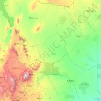
Name: Eastern topographic map, elevation, terrain.
Location: Eastern, East Kenya, Kenya (-1.42128 36.00258 3.77872 41.20258)
Average elevation: 677 m
Minimum elevation: 38 m
Maximum elevation: 4,637 m
Other topographic maps
Click on a map to view its topography, its elevation and its terrain.
Kakamega County
Kakamega County has an altitude ranging from 1,240 metres to 2,000 metres above sea level. The southern part of the county is hilly and made of granites which raises it 1950m above sea level. The Nandi Escarpment is a key feature on the eastern border of the county with steep cliffs rising from 1700m to 2000m.…
Average elevation: 1,660 m
Marsabit County
The county is located in central north Kenya. It borders the eastern shore of Lake Turkana. Important topographical features are: Ol Donyo Ranges 2,066 m [6,778 ft] in the southwest, Mount Marsabit 1,865 m [6,119 ft] in the central part of the county, Hurri Hills 1,685 m [5,528 ft] in the northeastern part of…
Average elevation: 699 m
Nairobi
Nairobi was founded in 1899 by colonial authorities in British East Africa, as a rail depot on the Uganda - Kenya Railway. The town quickly grew to replace Mombasa as the capital of Kenya in 1907. After independence in 1963, Nairobi became the capital of the Republic of Kenya. During Kenya's colonial period,…
Average elevation: 1,729 m
Elgeyo-Marakwet County
The Kerio River binds the county on the eastern side. From its alluvial plain the topography gradually rises towards the west. The Elgeyo Escarpment stands out distinctly and causes elevation differences of up to 1,500 m. In the northern and southern part of the county the topography is rugged, giving way to…
Average elevation: 1,730 m
Nyeri
Kenya > Nyeri > Nyeri Central
Nyeri has tarmacked roads, and the county and national governments are upgrading many of them. Houses have drinking water on tap, but sewage provision is through soak pits, pit latrines and septic tanks are still widespread. The city's topography allows nature and gravity to take care of most of the city's…
Average elevation: 1,796 m
Mombasa
Being a coastal town, Mombasa is characterised by a flat topography. The town of Mombasa is centred on Mombasa Island, but extends to the mainland. The island is separated from the mainland by two creeks, Port Reitz in the south and Tudor Creek in the north.
Average elevation: 18 m
Kisumu
Kisumu literally means a place of barter trade "sumo". The city has "Friendship" status with Cheltenham, United Kingdom and "sister city" status with Roanoke, Virginia and Boulder, Colorado, United States. It sits at an elevation of 1,131 m (3,711 ft). Kisumu is about 320 kilometers (200 miles) north west of…
Average elevation: 1,155 m
Nandi County
Nandi county is endowed with a scenic topography that is dotted with numerous tea plantations. These provide the raw material for the county's most vibrant agricultural industry, tea processing.
Average elevation: 1,887 m