
Elgeyo-Marakwet County topographic map
Interactive map
Click on the map to display elevation.
Elgeyo-Marakwet County
The Kerio River binds the county on the eastern side. From its alluvial plain the topography gradually rises towards the west. The Elgeyo Escarpment stands out distinctly and causes elevation differences of up to 1,500 m. In the northern and southern part of the county the topography is rugged, giving way to more subdued relief differences going westwards. The underlying geology mainly consists of gneisses from the Basement System. The Cherangany Hills rise gently to form the western half of the Great Rift Valley and extend northwest in a broken chain to Mount Moroto in Uganda. Non-volcanic in origin, the Cherangany Hills resulted from subsequent erosion of the raised western ridge of the Eastern Rift Valley. The range is approximately 30 miles (48 km) long and 25 miles (40 km) wide and averages 9,000 feet (2,700 metres) in height; its highest point reaches more than 11,000 feet (3,400 metres). Many of the summits are covered with huge groundsels and lobelias. Some of the hills include Kameleogon (3581 m), Chebon (3375 m), Chepkotet (3370 m), Alaleigelat (3350 m) and Sodang (3211 m).
About this map
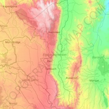
Name: Elgeyo-Marakwet County topographic map, elevation, terrain.
Location: Elgeyo-Marakwet County, Rift Valley, Kenya (0.16787 35.15229 1.31682 35.72309)
Average elevation: 1,730 m
Minimum elevation: 675 m
Maximum elevation: 3,506 m
Other topographic maps
Click on a map to view its topography, its elevation and its terrain.
Kibera
Kenya > Nairobi County > Kambi Muru
The third complicating factor is the unyielding topography and cramped sprawl of the area. Few houses have vehicle access, and many are at the bottoms of steep inclines (which heightens the flooding risk). This means that any construction efforts are made more difficult and costly by the fact that all…
Average elevation: 1,735 m
Mombasa
Kenya > Mombasa County > Mvita
Being a coastal town, Mombasa is characterised by a flat topography. The town of Mombasa is centred on Mombasa Island, but extends to the mainland. The island is separated from the mainland by two creeks, Port Reitz in the south and Tudor Creek in the north.
Average elevation: 32 m
Nyeri
Kenya > Nyeri > Nyeri Central
Nyeri has tarmacked roads, and the county and national governments are upgrading many of them. Houses have drinking water on tap, but sewage provision is through soak pits, pit latrines and septic tanks are still widespread. The city's topography allows nature and gravity to take care of most of the city's…
Average elevation: 1,796 m
Mombasa
Being a coastal town, Mombasa is characterised by a flat topography. The town of Mombasa is centred on Mombasa Island, but extends to the mainland. The island is separated from the mainland by two creeks, Port Reitz in the south and Tudor Creek in the north.
Average elevation: 18 m
Kisumu
Kisumu literally means a place of barter trade "sumo". The city has "Friendship" status with Cheltenham, United Kingdom and "sister city" status with Roanoke, Virginia and Boulder, Colorado, United States. It sits at an elevation of 1,131 m (3,711 ft). Kisumu is about 320 kilometers (200 miles) north west of…
Average elevation: 1,155 m