
Marsabit County topographic map
Interactive map
Click on the map to display elevation.
Marsabit County
The county is located in central north Kenya. It borders the eastern shore of Lake Turkana. Important topographical features are: Ol Donyo Ranges 2,066 m [6,778 ft] in the southwest, Mount Marsabit 1,865 m [6,119 ft] in the central part of the county, Hurri Hills 1,685 m [5,528 ft] in the northeastern part of the county, Mount Kulal 2,235 m [7,333 ft] in the northwest and the mountains around Sololo-Moyale escarpment up to 1,400 m [4,600 ft] in the northeast. The Chalbi Desert makes up much of the center region of the county.
About this map
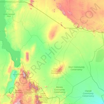
Name: Marsabit County topographic map, elevation, terrain.
Location: Marsabit County, Eastern, Kenya (1.26103 36.04932 4.45507 39.34650)
Average elevation: 699 m
Minimum elevation: 218 m
Maximum elevation: 2,806 m
Other topographic maps
Click on a map to view its topography, its elevation and its terrain.
Kibera
Kenya > Nairobi County > Kambi Muru
The third complicating factor is the unyielding topography and cramped sprawl of the area. Few houses have vehicle access, and many are at the bottoms of steep inclines (which heightens the flooding risk). This means that any construction efforts are made more difficult and costly by the fact that all…
Average elevation: 1,735 m
Mombasa
Kenya > Mombasa County > Mvita
Being a coastal town, Mombasa is characterised by a flat topography. The town of Mombasa is centred on Mombasa Island, but extends to the mainland. The island is separated from the mainland by two creeks, Port Reitz in the south and Tudor Creek in the north.
Average elevation: 32 m
Nyeri
Kenya > Nyeri > Nyeri Central
Nyeri has tarmacked roads, and the county and national governments are upgrading many of them. Houses have drinking water on tap, but sewage provision is through soak pits, pit latrines and septic tanks are still widespread. The city's topography allows nature and gravity to take care of most of the city's…
Average elevation: 1,796 m
Mombasa
Being a coastal town, Mombasa is characterised by a flat topography. The town of Mombasa is centred on Mombasa Island, but extends to the mainland. The island is separated from the mainland by two creeks, Port Reitz in the south and Tudor Creek in the north.
Average elevation: 18 m
Kisumu
Kisumu literally means a place of barter trade "sumo". The city has "Friendship" status with Cheltenham, United Kingdom and "sister city" status with Roanoke, Virginia and Boulder, Colorado, United States. It sits at an elevation of 1,131 m (3,711 ft). Kisumu is about 320 kilometers (200 miles) north west of…
Average elevation: 1,155 m