
Baxter County topographic map
Interactive map
Click on the map to display elevation.
Baxter County
Norfork Lake WMA is a series of protected walk-in hunting areas along Lake Norfork covered in hardwood forest with some pine and ranging topography. The four Baxter County units are Indian Head Unit, Chapin Point Unit, Seward Point Unit, and the Bennett's Creek Unit. The WMA is managed for deer, turkey and small game and attracts waterfowl during migration.
About this map
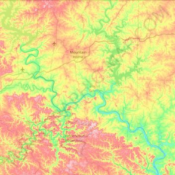
Name: Baxter County topographic map, elevation, terrain.
Location: Baxter County, Arkansas, United States (35.97355 -92.59547 36.49874 -92.15454)
Average elevation: 233 m
Minimum elevation: 95 m
Maximum elevation: 423 m
Other topographic maps
Click on a map to view its topography, its elevation and its terrain.
Park Addition
United States > Arkansas > Hempstead County > Hope > Park Addition
Average elevation: 102 m
North Fordyce
United States > Arkansas > Dallas County > Fordyce > North Fordyce
Average elevation: 79 m
Bella Vista
United States > Arkansas > Benton County > Bella Vista
The city of Bella Vista is located on the Springfield Plateau of the Ozark Mountains. Oak/hickory forests, along with valleys, creeks, and steep rises, characterize the city's topography. Bella Vista is located north of Bentonville and Rogers and is the northernmost Arkansas city in the Standard Metropolitan…
Average elevation: 371 m