
Caerphilly County Borough topographic map
Interactive map
Click on the map to display elevation.
About this map
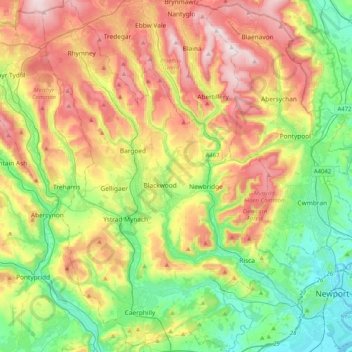
Name: Caerphilly County Borough topographic map, elevation, terrain.
Location: Caerphilly County Borough, Wales, United Kingdom (51.54564 -3.33446 51.79897 -3.06369)
Average elevation: 228 m
Minimum elevation: 0 m
Maximum elevation: 574 m
Other topographic maps
Click on a map to view its topography, its elevation and its terrain.
Snowdon
United Kingdom > Wales > Gwynedd
Snowdon (/ˈsnoʊdən/) or Yr Wyddfa (pronounced [ər ˈʊɨ̞̯ðva] (listen)) is the highest mountain in Wales, at an elevation of 1,085 metres (3,560 ft) above sea level, and the highest point in the British Isles outside the Scottish Highlands. It is located in Snowdonia National Park (Parc Cenedlaethol…
Average elevation: 692 m
Ruthin
United Kingdom > Wales > Denbighshire
The Myddleton Arms is also known as the Seven Eyes. It is said to have been built in the 14th century. The Dutch style design, long, steeped roof is attributed to Sir Richard Clough, an Elizabethan merchant. It has four tiers of dormer windows, each at a different elevation, known locally as the seven eyes of…
Average elevation: 162 m