Geolocate

Saint Mary's County topographic map

Interactive map

Click on the map to display elevation.

About this map

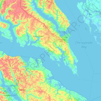
Name: Saint Mary's County topographic map, elevation, terrain.

Location: Saint Mary's County, Maryland, United States (37.89031 -76.87435 38.51371 -76.19967)

Average elevation: 13 m

Minimum elevation: -4 m

Maximum elevation: 62 m

Other topographic maps

Click on a map to view its topography, its elevation and its terrain.

Baltimore County

United States > Maryland

Baltimore County, Maryland, United States

Average elevation: 123 m

Forest Glen

United States > Maryland > Montgomery County > Forest Glen > McKenney Hills

Forest Glen, McKenney Hills, Forest Glen, Montgomery County, Maryland, United States

Average elevation: 105 m

Solomons Island

United States > Maryland > Calvert County > Solomons

Solomons Island, Solomons, Calvert County, Maryland, 20688, United States

Average elevation: 11 m

Deer Park Ridge

United States > Maryland > Carroll County

Deer Park Ridge, Carroll County, Maryland, 21048, United States

Average elevation: 156 m

Cumberland

United States > Maryland > Allegany County

Cumberland, Allegany County, Maryland, 21502, United States

Average elevation: 264 m

Assateague Island

United States > Maryland > Worcester County > West Ocean City

Assateague Island, West Ocean City, Worcester County, Maryland, United States

Average elevation: 3 m

Treetops

United States > Maryland > Baltimore County

Treetops, Baltimore County, Maryland, United States

Average elevation: 131 m

Gaithersburg

United States > Maryland > Montgomery County

Gaithersburg, Montgomery County, Maryland, United States

Average elevation: 137 m

Upperco

United States > Maryland > Baltimore County

Upperco, Baltimore County, Maryland, 21155, United States

Average elevation: 218 m

Easton Primary Sewage Lagoon Dam

United States > Maryland > Talbot County

Easton Primary Sewage Lagoon Dam, Talbot County, Maryland, United States

Average elevation: 9 m

Parkville

United States > Maryland > Baltimore County

Parkville, Baltimore County, Maryland, 21234, United States

Average elevation: 91 m

Stevensville

United States > Maryland > Queen Anne's County

Stevensville, Queen Anne's County, Maryland, United States

Average elevation: 2 m

Blackhole Creek

United States > Maryland > Anne Arundel County > Cape Sable

Blackhole Creek, Cape Sable, Anne Arundel County, Maryland, 21012, United States

Average elevation: 4 m

Simpsons Farm

United States > Maryland > Calvert County

Simpsons Farm, Calvert County, Maryland, 20736, United States

Average elevation: 38 m

Bradbury Park

United States > Maryland > Prince George's County > Suitland

Bradbury Park, Suitland, Prince George's County, Maryland, 20233, United States

Average elevation: 80 m

Bonnie Brook

United States > Maryland > Dorchester County

Bonnie Brook, Dorchester County, Maryland, United States

Average elevation: 5 m

Middle East

United States > Maryland > Baltimore

Middle East, Baltimore, Maryland, United States

Average elevation: 29 m

Calvert County

United States > Maryland

Calvert County, Maryland, United States

Average elevation: 18 m

Reisterstown

United States > Maryland > Baltimore County > Reisterstown

Reisterstown, Baltimore County, Maryland, 21136, United States

Average elevation: 199 m

Pikesville

United States > Maryland > Baltimore County > Pikesville

Pikesville, Baltimore County, Maryland, United States

Average elevation: 135 m

Skeleton Creek

United States > Maryland > Caroline County

Skeleton Creek, Caroline County, Maryland, 21609, United States

Average elevation: 5 m

Edmondson Village

United States > Maryland > Baltimore

Edmondson Village, Baltimore, Maryland, United States

Average elevation: 80 m

Middle River

United States > Maryland > Baltimore County > Middle River

Middle River, Baltimore County, Maryland, 21220, United States

Average elevation: 13 m

Forest Glen

United States > Maryland > Montgomery County

Forest Glen, Montgomery County, Maryland, 20895, United States

Average elevation: 96 m

White Marsh

United States > Maryland > Baltimore County > White Marsh

White Marsh, Baltimore County, Maryland, United States

Average elevation: 39 m

Woodberry

United States > Maryland > Baltimore

Woodberry, Baltimore, Maryland, United States

Average elevation: 94 m

Rosedale

United States > Maryland > Baltimore County > Rosedale

Rosedale, Baltimore County, Maryland, 21237, United States

Average elevation: 28 m

Mutual Consent

United States > Maryland > Calvert County

Mutual Consent, Calvert County, Maryland, 20676, United States

Average elevation: 32 m

Sams Creek

United States > Maryland > Frederick County

Sams Creek, Frederick County, Maryland, 21776, United States

Average elevation: 189 m

East Riverdale

United States > Maryland > Prince George's County > East Riverdale

East Riverdale, Prince George's County, Maryland, 20737, United States

Average elevation: 36 m

Rockville

United States > Maryland > Montgomery County

Rockville, Montgomery County, Maryland, United States

Average elevation: 122 m

Owings Mills

United States > Maryland > Baltimore County > Owings Mills

Owings Mills, Baltimore County, Maryland, 21117, United States

Average elevation: 173 m

Ferry Road

United States > Maryland > Wicomico County

Ferry Road, Wicomico County, Maryland, 21810, United States

Average elevation: 7 m

Dundalk

United States > Maryland > Baltimore County > Dundalk

Dundalk, Baltimore County, Maryland, 21222, United States

Average elevation: 6 m

Queensberry

United States > Maryland > Calvert County > Prince Frederick > Queensberry

Queensberry, Prince Frederick, Calvert County, Maryland, 20678, United States

Average elevation: 37 m

Jersey Island

United States > Maryland > Somerset County > Crisfield

Jersey Island, Crisfield, Somerset County, Maryland, 21817, United States

Average elevation: 2 m

Queenland

United States > Maryland > Prince George's County > Rosaryville

Queenland, Rosaryville, Prince George's County, Maryland, 20772, United States

Average elevation: 42 m

Jacksonville

United States > Maryland > Baltimore County > Jacksonville

Jacksonville, Baltimore County, Maryland, 21131, United States

Average elevation: 170 m

Washington, Baltimore & Annapolis Trail

United States > Maryland > Prince George's County > Bowie

Washington, Baltimore & Annapolis Trail, Bowie, Prince George's County, Maryland, United States

Average elevation: 31 m

Dargan

United States > Maryland > Washington County > Dargan

Dargan, Washington County, Maryland, 25410, United States

Average elevation: 158 m

Potomac Vista

United States > Maryland > Prince George's County > National Harbor > Potomac Vista

Potomac Vista, National Harbor, Prince George's County, Maryland, 20745-3027, United States

Average elevation: 26 m

Abell

United States > Maryland > Saint Mary's County > Abell

Abell, Saint Mary's County, Maryland, 20606, United States

Average elevation: 3 m

Frostburg

United States > Maryland > Allegany County > Frostburg

Frostburg, Allegany County, Maryland, 21532, United States

Average elevation: 620 m

Westernport

United States > Maryland > Allegany County > Westernport

Westernport, Allegany County, Maryland, United States

Average elevation: 400 m

Columbia

United States > Maryland > Howard County > Columbia

Columbia, Howard County, Maryland, United States

Average elevation: 114 m

Germantown

United States > Maryland > Montgomery County > Germantown

Germantown, Montgomery County, Maryland, United States

Average elevation: 130 m

Zekiah Valley

United States > Maryland > Charles County > Zekiah Valley

Zekiah Valley, Charles County, Maryland, 20617, United States

Average elevation: 44 m

Jackson Landing

United States > Maryland > Prince George's County > Jackson Landing

Jackson Landing, Prince George's County, Maryland, United States

Average elevation: 15 m

Long Green

United States > Maryland > Baltimore County > Towson > Long Green

Long Green, Towson, Baltimore County, Maryland, 21057, United States

Average elevation: 129 m

Catonsville

United States > Maryland > Baltimore County > Catonsville

Catonsville, Baltimore County, Maryland, United States

Average elevation: 105 m