
Paddington topographic map
Interactive map
Click on the map to display elevation.
Paddington
Paddington is a rare and largely intact example of an early Victorian residential suburb. Its unique qualities may be attributed to its close proximity to the city, the topography of its harbour location, the process of development and subdivision of early land grants, and the short period in the late l9thC in which it was largely built out.
About this map
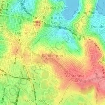
Name: Paddington topographic map, elevation, terrain.
Average elevation: 42 m
Minimum elevation: -2 m
Maximum elevation: 82 m
New South Wales trails, hiking, mountain biking, running and outdoor activities
Other topographic maps
Click on a map to view its topography, its elevation and its terrain.