
Gregory Hills topographic map
Interactive map
Click on the map to display elevation.
Gregory Hills
Gregory Hills is a suburb of Sydney in the state of New South Wales, Australia in Camden Council. The suburb was assigned on 1 August 2008. The suburb was named from the topography of the local area and from the original St Gregory's Chapel on the Marist Brothers land.
About this map
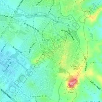
Name: Gregory Hills topographic map, elevation, terrain.
Average elevation: 109 m
Minimum elevation: 78 m
Maximum elevation: 191 m
New South Wales trails, hiking, mountain biking, running and outdoor activities
Other topographic maps
Click on a map to view its topography, its elevation and its terrain.