
Chengdu topographic map
Interactive map
Click on the map to display elevation.
About this map
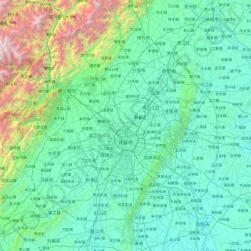
Name: Chengdu topographic map, elevation, terrain.
Location: Chengdu, Sichuan, China (30.09155 102.98962 31.43710 104.89485)
Average elevation: 913 m
Minimum elevation: 330 m
Maximum elevation: 5,323 m
The vast plain on which Chengdu is located has an elevation ranging from 450 to 720 meters (1,480 to 2,360 feet).
Other topographic maps
Click on a map to view its topography, its elevation and its terrain.
Xichang City
Xichang City, Liangshan, Sichuan, 615000, China
Average elevation: 2,319 m
Mount Gongga
China > Sichuan > Luding County
Mount Gongga, Luding County, Kardze Tibetan Autonomous Prefecture, Sichuan, China
Average elevation: 6,496 m
Mengzhuiwan
China > Sichuan > Chenghua District > Mengzhuiwan
Mengzhuiwan, Chenghua District, Chengdu City, Sichuan, 610054, China
Average elevation: 502 m