Geolocate
👉 Easily get elevation data in JSON, GeoTIFF and KML formats using Elevation API
Thank you for supporting this site ❤️
Make a donation

Gear up for your next adventure:

As an Amazon Associate, this site earns from qualifying purchases at no extra cost to you.

Noojee topographic map

Click on the map to display elevation.

About this map

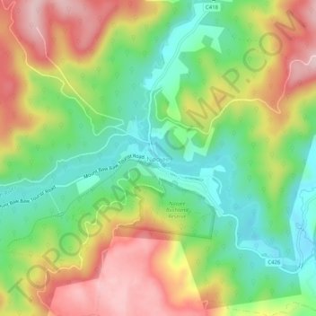
Name: Noojee topographic map, elevation, terrain.

Location: Noojee, Shire of Baw Baw, Victoria, 3833, Australia (-37.91335 145.98012 -37.87335 146.02012)

Average elevation: 334 m

Minimum elevation: 206 m

Maximum elevation: 499 m

Victoria trails, hiking, mountain biking, running and outdoor activities

Other topographic maps

Click on a map to view its topography, its elevation and its terrain.

City of Melbourne

Australia > Victoria

Melbourne's topography is characterized by a diverse landscape that transitions from flat coastal plains to rolling hills and mountainous regions. The city is situated at the northern end of Port Phillip Bay, where the terrain is predominantly flat, facilitating urban development. As one moves eastward, the…

Average elevation: 18 m

Bright

Australia > Victoria

Average elevation: 550 m

Melbourne

Australia > Victoria

Melbourne is also prone to isolated convective showers forming when a cold pool crosses the state, especially if there is considerable daytime heating. These showers are often heavy and can include hail, squalls, and significant drops in temperature, but they often pass through very quickly with a rapid…

Average elevation: 185 m

Point Cook

Australia > Victoria > Melbourne

Average elevation: 8 m

Rye

Australia > Victoria > Melbourne

Average elevation: 11 m

Thank you for supporting this site ❤️
Make a donation

Gear up for your next adventure:

As an Amazon Associate, this site earns from qualifying purchases at no extra cost to you.

Elwood

Australia > Victoria > Melbourne

Average elevation: 8 m

Halls Gap

Australia > Victoria

Average elevation: 406 m

Warrnambool

Australia > Victoria

Average elevation: 19 m

Port Phillip

Australia > Victoria

Port Phillip's mostly flat topography and moderate waves make perfect conditions for recreational swimming, kitesurfing, windsurfing, sailing, boating, snorkeling, scuba diving, stand up paddle boarding (SUP) and other sports.

Average elevation: 18 m

Melbourne

Australia > Victoria

Melbourne is also prone to isolated convective showers forming when a cold pool crosses the state, especially if there is considerable daytime heating. These showers are often heavy and can include hail, squalls, and significant drops in temperature, but they often pass through very quickly with a rapid…

Average elevation: 185 m

Thank you for supporting this site ❤️
Make a donation

Gear up for your next adventure:

As an Amazon Associate, this site earns from qualifying purchases at no extra cost to you.

Kennett River

Australia > Victoria

Average elevation: 185 m

Eltham District

Australia > Victoria > Greensborough

Average elevation: 85 m

Mount Waverley District

Australia > Victoria

Average elevation: 100 m

Mornington District

Australia > Victoria > Melbourne

Average elevation: 50 m

Glen Waverley

Australia > Victoria

Average elevation: 103 m

Thank you for supporting this site ❤️
Make a donation

Gear up for your next adventure:

As an Amazon Associate, this site earns from qualifying purchases at no extra cost to you.

Kyneton

Australia > Victoria

Average elevation: 504 m

Torquay

Australia > Victoria

Average elevation: 32 m

Melbourne

Australia > Victoria > Melbourne

Average elevation: 16 m

Brighton East

Australia > Victoria > Melbourne

Average elevation: 25 m

Strathbogie

Australia > Victoria

Average elevation: 535 m

Camberwell

Australia > Victoria > Melbourne

The Prospect Hill Road Precinct area is adjacent to the railway station and is the oldest part of the suburb. The original subdivision was relatively generous blocks, which were quickly filled with fine Victorian and Edwardian houses. Due to its hilly topography, many east–west streets in the Prospect Hill…

Average elevation: 66 m

Warrnambool

Australia > Victoria

Average elevation: 19 m

Phillip Island

Australia > Victoria > Ventnor

Average elevation: 5 m

Nanneella

Australia > Victoria

Average elevation: 109 m

Dandenong South

Australia > Victoria > Melbourne

Average elevation: 18 m

Thank you for supporting this site ❤️
Make a donation

Gear up for your next adventure:

As an Amazon Associate, this site earns from qualifying purchases at no extra cost to you.

Yarra River

Australia > Victoria > Melbourne

Average elevation: 86 m

Jells Park

Australia > Victoria > Melbourne

Average elevation: 71 m

Springmount

Australia > Victoria

Average elevation: 530 m

Trentham

Australia > Victoria

Trentham is a town in the Shire of Hepburn and Shire of Moorabool local government area of West Central Victoria, Australia. At the 2016 census, Trentham had a population of 1180, with a median age of 55 years. Located at an altitude of 700 metres (2,297 ft), the town is 87 kilometres (54 miles) north-west of…

Average elevation: 702 m

Driffield

Australia > Victoria

Average elevation: 136 m

Thank you for supporting this site ❤️
Make a donation

Gear up for your next adventure:

As an Amazon Associate, this site earns from qualifying purchases at no extra cost to you.

Banyan

Australia > Victoria

Average elevation: 76 m

Castlemaine

Australia > Victoria

The Castlemaine goldfields' legendary prosperity raised expectations of Castlemaine becoming Victoria's second city. That is reflected in imposing buildings erected in the town's first few years. Though the rich alluvial diggings were largely exhausted within 15–20 years causing the town's population to…

Average elevation: 319 m

Anglesea

Australia > Victoria

Average elevation: 60 m

Mount Martha

Australia > Victoria > Melbourne

Average elevation: 40 m

Mount Eliza

Australia > Victoria > Melbourne

Average elevation: 60 m

Great Otway National Park

Australia > Victoria

Average elevation: 91 m

Ensay

Australia > Victoria

Average elevation: 416 m

Glenrowan

Australia > Victoria

Average elevation: 210 m

Cape Woolamai

Australia > Victoria

Average elevation: 6 m

Rye

Australia > Victoria > Melbourne

Average elevation: 11 m

Cumberland River

Australia > Victoria > Lorne

Average elevation: 273 m

Kangaroo Flat

Australia > Victoria > Bendigo

Average elevation: 283 m

Korumburra

Australia > Victoria

Average elevation: 178 m

Newport Lakes Reserve

Australia > Victoria > Melbourne

Average elevation: 15 m

Thank you for supporting this site ❤️
Make a donation

Gear up for your next adventure:

As an Amazon Associate, this site earns from qualifying purchases at no extra cost to you.

Gaffneys Creek

Australia > Victoria

Average elevation: 847 m

Heidelberg West

Australia > Victoria > Melbourne

Average elevation: 73 m

Highlands

Australia > Victoria

Average elevation: 431 m

Cowes

Australia > Victoria

Average elevation: 27 m

Bacchus Marsh

Australia > Victoria

Average elevation: 139 m

Eskdale

Australia > Victoria

Average elevation: 589 m

Wedderburn

Australia > Victoria

Average elevation: 206 m

Moyston

Australia > Victoria

Average elevation: 285 m

Glenlyon

Australia > Victoria

Average elevation: 513 m

Melbourne District

Australia > Victoria > Melbourne

Average elevation: 20 m

Calembeen Lake

Australia > Victoria > Creswick

Average elevation: 436 m

Linton

Australia > Victoria

Average elevation: 366 m

Burnside Heights

Australia > Victoria > Melbourne

Average elevation: 83 m

Skye

Australia > Victoria > Melbourne

Average elevation: 35 m

Rochester

Australia > Victoria > Rochester

Average elevation: 117 m

Swan Reach

Australia > Victoria

Average elevation: 50 m

Foster

Australia > Victoria

Average elevation: 81 m

Fontainbleu Dam

Australia > Victoria

Average elevation: 181 m

Gippsland

Australia > Victoria

Average elevation: 273 m

Thank you for supporting this site ❤️
Make a donation

Gear up for your next adventure:

As an Amazon Associate, this site earns from qualifying purchases at no extra cost to you.

Frankston

Australia > Victoria > Melbourne

Olivers Hill is the most prominent elevation in Frankston which rises to 55 metres above sea level (180 feet) at its highest point in the suburb. Its origins date to approximately 415 to 360 million years ago. Its base is Mount Eliza Granite dating from the Devonian period, which was covered in lava tuffs in…

Average elevation: 40 m

Shire of Yarriambiack

Australia > Victoria

Average elevation: 107 m

Yarra Junction

Australia > Victoria > Melbourne

Average elevation: 166 m

Fitzroy

Australia > Victoria > Melbourne

Fitzroy's topography is flat. It is laid out in grid plan and is characterised by a fairly tightly spaced rectangular grid of medium-sized streets, with many of its narrow streets and back lanes facilitating only one-way traffic. Its built form is a legacy of its early history when a mixture of land uses was…

Average elevation: 35 m

Smiths Gully

Australia > Victoria > Melbourne

Average elevation: 201 m

Thank you for supporting this site ❤️
Make a donation

Gear up for your next adventure:

As an Amazon Associate, this site earns from qualifying purchases at no extra cost to you.

Blairgowrie

Australia > Victoria > Melbourne

Average elevation: 7 m

Melbourne

Australia > Victoria

Melbourne is also prone to isolated convective showers forming when a cold pool crosses the state, especially if there is considerable daytime heating. These showers are often heavy and can include hail, squalls, and significant drops in temperature, but they often pass through very quickly with a rapid…

Average elevation: 185 m

Boneo

Australia > Victoria > Melbourne

Average elevation: 64 m

Emerald

Australia > Victoria > Melbourne

Average elevation: 225 m

Werribee

Australia > Victoria > Melbourne

Average elevation: 22 m

Grampians National Park

Australia > Victoria

Mount William is known within the gliding community for the "Grampians Wave", a weather phenomenon that sometimes enables glider pilots to reach extreme altitudes of the order of 28,000 ft (8,500 m). This predominantly occurs during the months of May, June, September and October when strong westerly winds flow…

Average elevation: 262 m

Linga

Australia > Victoria

Average elevation: 57 m

East Melbourne

Australia > Victoria > Melbourne

Average elevation: 24 m

Grassdale

Australia > Victoria

Average elevation: 146 m

Thank you for supporting this site ❤️
Make a donation

Gear up for your next adventure:

As an Amazon Associate, this site earns from qualifying purchases at no extra cost to you.

Longwood

Australia > Victoria

Average elevation: 214 m

Bridge Creek

Australia > Victoria

Average elevation: 530 m

Badger Creek

Australia > Victoria > Melbourne

Average elevation: 172 m

Merbein

Australia > Victoria

Average elevation: 45 m

Sunbury

Australia > Victoria > Melbourne

Average elevation: 275 m

Thank you for supporting this site ❤️
Make a donation

Gear up for your next adventure:

As an Amazon Associate, this site earns from qualifying purchases at no extra cost to you.

Kew

Australia > Victoria > Melbourne

Average elevation: 38 m

Pakenham

Australia > Victoria > Melbourne

Average elevation: 56 m

Echuca

Australia > Victoria

Average elevation: 100 m

Warburton

Australia > Victoria > Melbourne

Average elevation: 525 m

Queenscliff

Australia > Victoria

Average elevation: 1 m

Thank you for supporting this site ❤️
Make a donation

Gear up for your next adventure:

As an Amazon Associate, this site earns from qualifying purchases at no extra cost to you.

Kangaroo Ground

Australia > Victoria > Melbourne

Average elevation: 123 m

Mount Lofty Park

Australia > Victoria > Melbourne

Average elevation: 89 m

Mallacoota

Australia > Victoria

Average elevation: 68 m

Heyfield

Australia > Victoria

Average elevation: 61 m

Freeburgh

Australia > Victoria

Average elevation: 672 m

Metung

Australia > Victoria

Average elevation: 11 m

Footscray

Australia > Victoria > Melbourne

Average elevation: 19 m

Lake Carchap

Australia > Victoria

Average elevation: 148 m

Clarendon

Australia > Victoria > Clarendon

Average elevation: 439 m

City of Monash

Australia > Victoria

Average elevation: 78 m

Gear up for your next adventure:

🧤Thermal Hiking Gloves - Keep your hands warm and functional during high-altitude winter treks
🔦LED Torches - LED torches for outdoor use
🎒3L Hydration Reservoirs - Hands-free drinking to stay hydrated on steep contour climbs

As an Amazon Associate, this site earns from qualifying purchases at no extra cost to you.