
Launceston topographic map
Interactive map
Click on the map to display elevation.
About this map
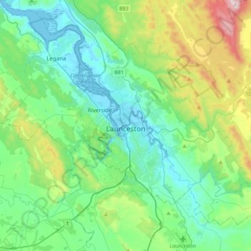
Name: Launceston topographic map, elevation, terrain.
Location: Launceston, City of Launceston, Tasmania, Australia (-41.52687 146.97218 -41.33457 147.30525)
Average elevation: 194 m
Minimum elevation: -3 m
Maximum elevation: 855 m
Launceston is at 41°26′31″S 147°8′42″E / 41.44194°S 147.14500°E / -41.44194; 147.14500 in the Tamar Valley, Northern Tasmania. The valley was formed by volcanic and glacial forces over 10 million years ago. The city is about 45 kilometres (28 mi) south of the Bass Strait, with its closest neighbour-city being Devonport, about 99 kilometres (62 mi) to the north west. Launceston combines steep (originally heavily wooded) ridges and low-lying areas (originally wetlands – with parts of the suburbs of Inveresk and Invermay below high-tide level). As a result, areas of Launceston are subject to landslip problems, while others are liable to poor drainage and periodic flooding. The topography of the area is not conducive to easy dispersion of airborne pollution, due to the phenomenon of thermal inversion.
Other topographic maps
Click on a map to view its topography, its elevation and its terrain.
Cradle Mountain
Australia > Tasmania > Cradle Mountain
Cradle Mountain, Cradle Mount Summit Track, Cradle Mountain, Meander Valley, Tasmania, Australia
Average elevation: 1,144 m
Launceston
Australia > Tasmania > Launceston
Launceston, Tasmania, 7250, Australia
Average elevation: 218 m
West Kentish
West Kentish, Kentish, Tasmania, 7306, Australia
Average elevation: 291 m
Mount Lloyd
Mount Lloyd, Derwent Valley, Tasmania, 7140, Australia
Average elevation: 558 m
West Ulverstone
Australia > Tasmania > Ulverstone
West Ulverstone, Ulverstone, Central Coast, Tasmania, 7315, Australia
Average elevation: 26 m
Connellys Marsh
Connellys Marsh, Sorell, Tasmania, 7173, Australia
Average elevation: 41 m
Mount Direction
Mount Direction, Hobart, City of Clarence, Tasmania, 7017, Australia
Average elevation: 166 m
Styx River
Australia > Tasmania > Westerway
Styx River, Westerway, Derwent Valley, Tasmania, Australia
Average elevation: 548 m
West Montagu
West Montagu, Circular Head, Tasmania, 7330, Australia
Average elevation: 35 m
Bruny Island
Australia > Tasmania > Alonnah
Bruny Island, Alonnah, Kingborough, Tasmania, Australia
Average elevation: 59 m
Arthurs Lake
Arthurs Lake, Central Highlands, Tasmania, 7030, Australia
Average elevation: 910 m
Garden Island Creek
Garden Island Creek, Huon Valley, Tasmania, 7112, Australia
Average elevation: 153 m
Lower Turners Marsh
Lower Turners Marsh, City of Launceston, Tasmania, 7267, Australia
Average elevation: 141 m
Lower Longley
Lower Longley, Hobart, Kingborough, Tasmania, 7109, Australia
Average elevation: 338 m
Greens Beach
Greens Beach, West Tamar, Tasmania, 7270, Australia
Average elevation: 30 m
Launceston
Launceston, City of Launceston, Tasmania, 7250, Australia
Average elevation: 26 m
Claude Road
Claude Road, Kentish, Tasmania, 7306, Australia
Average elevation: 444 m
Chain Of Lagoons
Chain Of Lagoons, Break O'Day, Tasmania, 7215, Australia
Average elevation: 154 m
Black Hills
Black Hills, Derwent Valley, Tasmania, 7140, Australia
Average elevation: 432 m
Deddington
Deddington, Northern Midlands, Tasmania, 7212, Australia
Average elevation: 358 m
Selfs Point
Selfs Point, New Town, Hobart, City of Hobart, Tasmania, 7008, Australia
Average elevation: 17 m
Mount Wellington
Mount Wellington, City of Hobart, Tasmania, Australia
Average elevation: 941 m
Lake Murchison
Australia > Tasmania > Tullah > Lake St Clair
Lake Murchison, Lake St Clair, Tullah, West Coast, Tasmania, Australia
Average elevation: 531 m
Lower Barrington
Lower Barrington, Kentish, Tasmania, 7306, Australia
Average elevation: 202 m
Barrington
Barrington, Kentish, Tasmania, 7306, Australia
Average elevation: 228 m