
San Vicente del Caguán topographic map
Interactive map
Click on the map to display elevation.
About this map
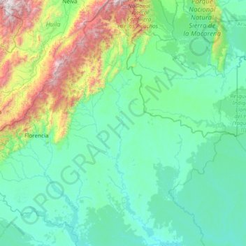
Name: San Vicente del Caguán topographic map, elevation, terrain.
Average elevation: 585 m
Minimum elevation: 172 m
Maximum elevation: 3,783 m
Other topographic maps
Click on a map to view its topography, its elevation and its terrain.
Villa Lobos
Colômbia > Caquetá > San Vicente del Caguán
Villa Lobos, San Vicente del Caguán, Caquetá, RAP Amazonía, Colômbia
Average elevation: 248 m
Azabache
Colômbia > Caquetá > Belén de los Andaquíes
Azabache, Belén de los Andaquíes, Caquetá, Colômbia
Average elevation: 253 m