
Florencia topographic map
Interactive map
Click on the map to display elevation.
About this map
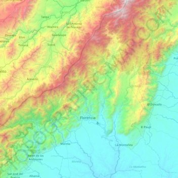
Name: Florencia topographic map, elevation, terrain.
Location: Florencia, Caquetá, RAP Amazonía, Colômbia (1.31822 -75.83544 2.19542 -75.34126)
Average elevation: 1,034 m
Minimum elevation: 211 m
Maximum elevation: 3,414 m
Other topographic maps
Click on a map to view its topography, its elevation and its terrain.
Villa Lobos
Colômbia > Caquetá > San Vicente del Caguán
Villa Lobos, San Vicente del Caguán, Caquetá, RAP Amazonía, Colômbia
Average elevation: 248 m
San Vicente del Caguán
San Vicente del Caguán, Caquetá, RAP Amazonía, 182010, Colômbia
Average elevation: 585 m
Azabache
Colômbia > Caquetá > Belén de los Andaquíes
Azabache, Belén de los Andaquíes, Caquetá, Colômbia
Average elevation: 253 m