
Caquetá topographic map
Interactive map
Click on the map to display elevation.
About this map
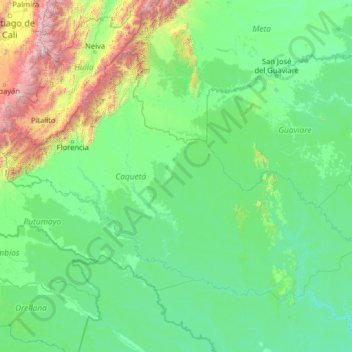
Name: Caquetá topographic map, elevation, terrain.
Location: Caquetá, Colômbia (-1.44466 -76.66568 3.67534 -71.54568)
Average elevation: 489 m
Minimum elevation: 91 m
Maximum elevation: 4,998 m
Other topographic maps
Click on a map to view its topography, its elevation and its terrain.
Villa Lobos
Colômbia > Caquetá > San Vicente del Caguán
Villa Lobos, San Vicente del Caguán, Caquetá, RAP Amazonía, Colômbia
Average elevation: 248 m
San Vicente del Caguán
San Vicente del Caguán, Caquetá, RAP Amazonía, 182010, Colômbia
Average elevation: 585 m
Azabache
Colômbia > Caquetá > Belén de los Andaquíes
Azabache, Belén de los Andaquíes, Caquetá, Colômbia
Average elevation: 253 m