
南城街道 topographic map
Interactive map
Click on the map to display elevation.
About this map
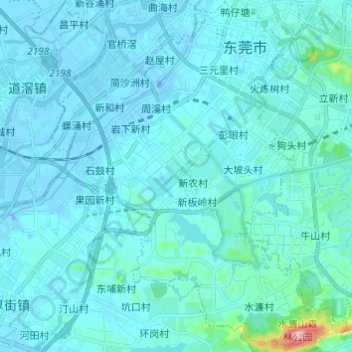
Name: 南城街道 topographic map, elevation, terrain.
Location: 南城街道, 东莞市, 广东省, 中国 (22.92324 113.68093 23.03506 113.78229)
Average elevation: 25 m
Minimum elevation: -22 m
Maximum elevation: 362 m
南城街道位于东莞市中部偏西南,在城市中心区之南,东部与东城街道接壤,南部与厚街镇、大岭山镇接壤,西部与万江街道隔河相望,北部与莞城街道接壤。面积56.6平方公里。地势北低南高,东南部多山岭,属丘陵地带,地面高度在海拔130-150米之间;西北部为冲积平原,属东江南支流水域地带。
Other topographic maps
Click on a map to view its topography, its elevation and its terrain.