
Ghorepani topographic map
Interactive map
Click on the map to display elevation.
About this map
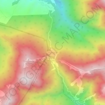
Name: Ghorepani topographic map, elevation, terrain.
Location: Ghorepani, Ghara, Annapurna, म्याग्दी, Gandaki, Népal (28.38249 83.67993 28.42249 83.71993)
Average elevation: 2,796 m
Minimum elevation: 2,282 m
Maximum elevation: 3,217 m
Other topographic maps
Click on a map to view its topography, its elevation and its terrain.
Dhaulagiri
Dhaulagiri, Mudi, Dhaulagiri, म्याग्दी, Gandaki, Népal
Average elevation: 7,321 m