Geolocate

Chitre topographic map

Interactive map

Click on the map to display elevation.

About this map

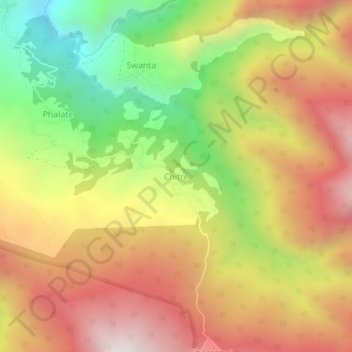
Name: Chitre topographic map, elevation, terrain.

Location: Chitre, Shikha, Annapurna, म्याग्दी, Gandaki, Népal (28.40255 83.67549 28.44255 83.71549)

Average elevation: 2,508 m

Minimum elevation: 1,845 m

Maximum elevation: 3,096 m

Other topographic maps

Click on a map to view its topography, its elevation and its terrain.

Khibang

Népal > म्याग्दी

Khibang, Ghara, Annapurna, म्याग्दी, Gandaki, Népal

Average elevation: 1,955 m

Ghorepani

Népal > म्याग्दी

Ghorepani, Ghara, Annapurna, म्याग्दी, Gandaki, Népal

Average elevation: 2,796 m

Darbang

Népal > म्याग्दी

Darbang, Malika, म्याग्दी, Gandaki, 33208, Népal

Average elevation: 1,744 m

Tatopani

Népal > म्याग्दी

Tatopani, Annapurna, म्याग्दी, Gandaki, Népal

Average elevation: 2,031 m

Dhaulagiri

Népal > म्याग्दी > Mudi

Dhaulagiri, Mudi, Dhaulagiri, म्याग्दी, Gandaki, Népal

Average elevation: 7,321 m