
Dharapani topographic map
Interactive map
Click on the map to display elevation.
About this map
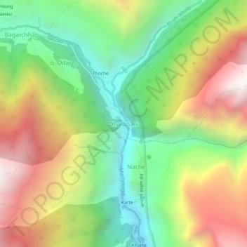
Name: Dharapani topographic map, elevation, terrain.
Location: Dharapani, Nashong, मनाङ, Gandaki, 33500, Népal (28.49900 84.33838 28.53900 84.37838)
Average elevation: 2,525 m
Minimum elevation: 1,771 m
Maximum elevation: 3,495 m
Other topographic maps
Click on a map to view its topography, its elevation and its terrain.
Tilicho Lake
Tilicho Lake, Neshyang-09, Neshyang, मनाङ, Gandaki, Népal
Average elevation: 5,062 m