
मनाङ topographic map
Interactive map
Click on the map to display elevation.
About this map
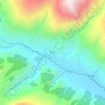
Name: मनाङ topographic map, elevation, terrain.
Location: मनाङ, Neshyang, मनाङ, Gandaki, Népal (28.64611 84.00312 28.68611 84.04312)
Average elevation: 3,855 m
Minimum elevation: 3,456 m
Maximum elevation: 4,781 m
Other topographic maps
Click on a map to view its topography, its elevation and its terrain.
Tilicho Lake
Tilicho Lake, Neshyang-09, Neshyang, मनाङ, Gandaki, Népal
Average elevation: 5,062 m