
Make a donation
Gear up for your next adventure:
As an Amazon Associate, this site earns from qualifying purchases at no extra cost to you.
Imo State topographic map
Click on the map to display elevation.
Make a donation
Gear up for your next adventure:
As an Amazon Associate, this site earns from qualifying purchases at no extra cost to you.
About this map
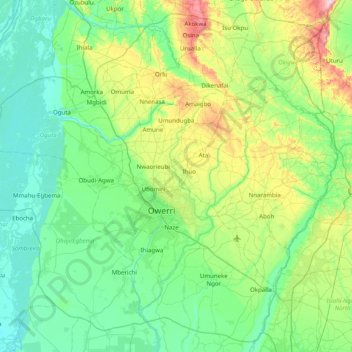
Name: Imo State topographic map, elevation, terrain.
Location: Imo State, Nigeria (5.19455 6.63908 5.93893 7.43229)
Average elevation: 89 m
Minimum elevation: 4 m
Maximum elevation: 415 m
Make a donation
Gear up for your next adventure:
As an Amazon Associate, this site earns from qualifying purchases at no extra cost to you.
Other topographic maps
Click on a map to view its topography, its elevation and its terrain.
Make a donation
Gear up for your next adventure:
As an Amazon Associate, this site earns from qualifying purchases at no extra cost to you.
Bakura Tureta Native Area Forest Reserve
Nigeria > Zamfara State > Bakura > Danmanau
Average elevation: 346 m
Make a donation
Gear up for your next adventure:
As an Amazon Associate, this site earns from qualifying purchases at no extra cost to you.
Shuwari Low-Cost
Nigeria > Borno > Damboa > Damboa Central > Shuwari Low-Cost
Average elevation: 392 m
Make a donation
Gear up for your next adventure:
As an Amazon Associate, this site earns from qualifying purchases at no extra cost to you.
Make a donation
Gear up for your next adventure:
As an Amazon Associate, this site earns from qualifying purchases at no extra cost to you.