
Ku-ring-gai Chase National Park topographic map
Interactive map
Click on the map to display elevation.
Ku-ring-gai Chase National Park
Ku-ring-gai Chase is part of the Hornsby Plateau, a massive block of sandstone tilting upwards to the north. The park comprises a plateau with an elevation of generally 150–200 m above sea level. Between 250 and 200 million years ago, sand silt and mud was deposited by rivers across flood plains. These formed the shales, flagstones and sandstones of the Narrabeen Group that outcrop along the foreshores and ridges. Higher areas of the park are underlain with pink, white and orange layers of Hawkesbury Sandstone that contain small beds of shale. Wianamatta Group shale is present in the higher points of the park. The park's terraced landscape is due to the horizontal arrangement of these sediment layers.
About this map
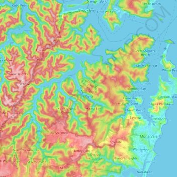
Name: Ku-ring-gai Chase National Park topographic map, elevation, terrain.
Average elevation: 83 m
Minimum elevation: -4 m
Maximum elevation: 230 m
New South Wales trails, hiking, mountain biking, running and outdoor activities
Other topographic maps
Click on a map to view its topography, its elevation and its terrain.