
Whatcom County topographic map
Interactive map
Click on the map to display elevation.
About this map
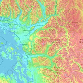
Name: Whatcom County topographic map, elevation, terrain.
Location: Whatcom County, Washington, VS (48.63525 -123.32224 49.00244 -120.65468)
Average elevation: 753 m
Minimum elevation: -3 m
Maximum elevation: 3,194 m
Other topographic maps
Click on a map to view its topography, its elevation and its terrain.
Mount Saint Helens
VS > Washington
Mount Saint Helens, Skamania County, Washington, VS
Average elevation: 2,108 m
Mount Vernon
VS > Washington > Mount Vernon
Mount Vernon, Skagit County, Washington, VS
Average elevation: 37 m
Maple Valley
VS > Washington > Maple Valley
Maple Valley, King County, Washington, 98038, VS
Average elevation: 160 m
First Hill
VS > Washington > Mercer Island
First Hill, Mercer Island, King County, Washington, 98040, VS
Average elevation: 31 m
North Cascades National Park
VS > Washington
North Cascades National Park, Whatcom County, Washington, VS
Average elevation: 1,151 m