
Columbia County topographic map
Interactive map
Click on the map to display elevation.
About this map
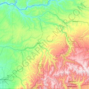
Name: Columbia County topographic map, elevation, terrain.
Location: Columbia County, Washington, VS (45.99889 -118.24264 46.62477 -117.60311)
Average elevation: 766 m
Minimum elevation: 161 m
Maximum elevation: 1,936 m
Other topographic maps
Click on a map to view its topography, its elevation and its terrain.
Mount Saint Helens
VS > Washington
Mount Saint Helens, Skamania County, Washington, VS
Average elevation: 2,108 m
Mount Vernon
VS > Washington > Mount Vernon
Mount Vernon, Skagit County, Washington, VS
Average elevation: 37 m
Maple Valley
VS > Washington > Maple Valley
Maple Valley, King County, Washington, 98038, VS
Average elevation: 160 m
First Hill
VS > Washington > Mercer Island
First Hill, Mercer Island, King County, Washington, 98040, VS
Average elevation: 31 m
North Cascades National Park
VS > Washington
North Cascades National Park, Whatcom County, Washington, VS
Average elevation: 1,151 m