
Make a donation
Gear up for your next adventure:
As an Amazon Associate, this site earns from qualifying purchases at no extra cost to you.
Eastern Cape topographic map
Click on the map to display elevation.
Make a donation
Gear up for your next adventure:
As an Amazon Associate, this site earns from qualifying purchases at no extra cost to you.
About this map
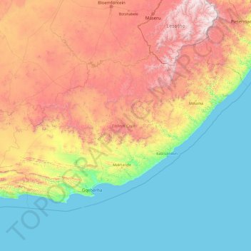
Name: Eastern Cape topographic map, elevation, terrain.
Location: Eastern Cape, South Africa (-34.41337 22.73574 -30.00180 30.37193)
Average elevation: 778 m
Minimum elevation: 0 m
Maximum elevation: 3,405 m
Make a donation
Gear up for your next adventure:
As an Amazon Associate, this site earns from qualifying purchases at no extra cost to you.
Other topographic maps
Click on a map to view its topography, its elevation and its terrain.
Durban North
South Africa > KwaZulu-Natal > eThekwini Metropolitan Municipality
Average elevation: 41 m
Franschhoek
South Africa > Western Cape > Cape Winelands District Municipality > Stellenbosch Local Municipality
Average elevation: 502 m
Thornlands
South Africa > Limpopo > Waterberg District Municipality > Lephalale Local Municipality
Average elevation: 867 m
City of Johannesburg Metropolitan Municipality
South Africa > Gauteng > City of Johannesburg Metropolitan Municipality
Average elevation: 1,615 m
Make a donation
Gear up for your next adventure:
As an Amazon Associate, this site earns from qualifying purchases at no extra cost to you.
Great Karoo
South Africa > Western Cape > Central Karoo District Municipality > Beaufort West Local Municipality
Average elevation: 853 m
Swellendam
South Africa > Western Cape > Overberg District Municipality > Swellendam Local Municipality
Average elevation: 232 m
Alberton
South Africa > Gauteng > City of Ekurhuleni Metropolitan Municipality
Alberton lies at an elevation of approximately 1,570 m (5,150 ft) above sea level on the banks of the Natal Spruit, approximately 11 km south-east of Johannesburg CBD, 59 km south of Pretoria and 49 km north-east of Vereeniging. Organisationally and administratively, it is included in the City of Ekurhuleni…
Average elevation: 1,617 m
Make a donation
Gear up for your next adventure:
As an Amazon Associate, this site earns from qualifying purchases at no extra cost to you.
Bethelsdorp
South Africa > Eastern Cape > Nelson Mandela Bay Metropolitan Municipality
Average elevation: 85 m
Uitkyk
South Africa > Western Cape > West Coast District Municipality > Matzikama Local Municipality
Average elevation: 54 m
Mtunzini
South Africa > KwaZulu-Natal > King Cetswayo District Municipality > uMlalazi Local Municipality
Average elevation: 30 m
Alice
South Africa > Eastern Cape > Amathole District Municipality > Nkonkobe Local Municipality
The location was named Lovedale by European missionaries who settled there in 1824.It lies on the southwestern bank of the Tyhume River, west-northwest of East London, at an elevation of 1,720(524m).It was named after John Love of the Glasgow Missionary Society. During the Frontier War it was abandoned and the…
Average elevation: 586 m
Make a donation
Gear up for your next adventure:
As an Amazon Associate, this site earns from qualifying purchases at no extra cost to you.
Carnarvon
South Africa > Northern Cape > Pixley ka Seme District Municipality > Kareeberg Local Municipality
Average elevation: 1,272 m
Cofimvaba
South Africa > Eastern Cape > Chris Hani District Municipality > Intsika Yethu Local Municipality
Average elevation: 997 m
Phongola Bush Nature Reserve
South Africa > KwaZulu-Natal > Zululand District Municipality > eDumbe Local Municipality
Average elevation: 1,511 m
Make a donation
Gear up for your next adventure:
As an Amazon Associate, this site earns from qualifying purchases at no extra cost to you.
Richmond
South Africa > KwaZulu-Natal > uMgungundlovu District Municipality > Richmond Local Municipality
Average elevation: 907 m
Bloemfontein
South Africa > Free State > Mangaung Metropolitan Municipality
Situated at an elevation of 1,395 m (4,577 ft) above sea level, the city is home to 256,185 (as of 2011) residents and forms part of the Mangaung Metropolitan Municipality which has a population of 747,431. It was one of the host cities for the 2010 FIFA World Cup.
Average elevation: 1,374 m
Port Alfred
South Africa > Eastern Cape > Sarah Baartman District Municipality > Ndlambe Local Municipality
Average elevation: 33 m
Make a donation
Gear up for your next adventure:
As an Amazon Associate, this site earns from qualifying purchases at no extra cost to you.
Germiston Lake
South Africa > Gauteng > City of Ekurhuleni Metropolitan Municipality > Germiston
Average elevation: 1,655 m
Humansdorp
South Africa > Eastern Cape > Sarah Baartman District Municipality > Kouga Local Municipality
Average elevation: 146 m
Pretoria
South Africa > Gauteng > City of Tshwane Metropolitan Municipality
Pretoria is situated approximately 56 km (35 mi) north-northeast of Johannesburg in the northeast of South Africa, in a transitional belt between the plateau of the Highveld to the south and the lower-lying Bushveld to the north. It lies at an altitude of about 1,339 m (4,393 ft) above sea level, in a warm,…
Average elevation: 1,363 m
Make a donation
Gear up for your next adventure:
As an Amazon Associate, this site earns from qualifying purchases at no extra cost to you.
Ballito
South Africa > KwaZulu-Natal > iLembe District Municipality > KwaDukuza Local Municipality
Average elevation: 31 m
Aliwal North
South Africa > Eastern Cape > Joe Gqabi District Municipality > Maletswai Local Municipality
Average elevation: 1,336 m
Ngaqamadolo (Ntshupe)
South Africa > KwaZulu-Natal > uMgungundlovu District Municipality > Impendle Local Municipality
Average elevation: 2,760 m
Make a donation
Gear up for your next adventure:
As an Amazon Associate, this site earns from qualifying purchases at no extra cost to you.
Khowa (Elliot)
South Africa > Eastern Cape > Chris Hani District Municipality > Sakhisizwe Local Municipality
Average elevation: 1,497 m
Friemersheim
South Africa > Western Cape > Garden Route District Municipality > Mossel Bay Local Municipality
Average elevation: 262 m
Meloding
South Africa > Free State > Lejweleputswa District Municipality > Matjhabeng Local Municipality
Average elevation: 1,340 m
Make a donation
Gear up for your next adventure:
As an Amazon Associate, this site earns from qualifying purchases at no extra cost to you.
Koffiefontein
South Africa > Free State > Xhariep District Municipality > Letsemeng Local Municipality
Average elevation: 1,203 m
Clanwilliam
South Africa > Western Cape > West Coast District Municipality > Cederberg Local Municipality
Clanwilliam is situated at an elevation of 100 metres (330 ft), between the western slopes of the Cederberg mountains and the east bank of the Olifants River, which is impounded there by the Clanwilliam Dam. It is located just off the N7 national road, which runs from Cape Town to the Namibian border, and on…
Average elevation: 162 m
Komatipoort
South Africa > Mpumalanga > Ehlanzeni District Municipality > Nkomazi
Average elevation: 173 m
Make a donation
Gear up for your next adventure:
As an Amazon Associate, this site earns from qualifying purchases at no extra cost to you.
Mossel Bay
South Africa > Western Cape > Garden Route District Municipality > Mossel Bay Local Municipality
To the east, the land slopes upwards towards the wave-cut platform (average elevation 245 metres) that characterises the more lush all-year-round rainfall area of the Garden Route. Here the land is mostly covered by grass and farmlands. The deep sandy soils of the western portion of the municipal area also…
Average elevation: 16 m
Chatsworth
South Africa > KwaZulu-Natal > eThekwini Metropolitan Municipality
Average elevation: 149 m
Make a donation
Gear up for your next adventure:
As an Amazon Associate, this site earns from qualifying purchases at no extra cost to you.
Pietermaritzburg
South Africa > KwaZulu-Natal > uMgungundlovu District Municipality
Average elevation: 853 m
Swinburne
South Africa > Free State > Thabo Mofutsanyana District Municipality > Maluti-a-Phofung Local Municipality
Average elevation: 1,678 m
Lochiel
South Africa > Mpumalanga > Albert Luthuli Local Municipality > Lochiel
Average elevation: 1,600 m
Make a donation
Gear up for your next adventure:
As an Amazon Associate, this site earns from qualifying purchases at no extra cost to you.
Kimberley
South Africa > Northern Cape > Frances Baard District Municipality > Kimberley
Kimberley is set in a relatively flat landscape with no prominent topographic features within the urban limits. The only "hills" are debris dumps generated by more than a century of diamond mining. From the 1990s these were being recycled and poured back into De Beers Mine (by 2010 it was filled to within a…
Average elevation: 1,191 m
Cradock
South Africa > Eastern Cape > Chris Hani District Municipality > Inxuba Yethemba Local Municipality
Average elevation: 940 m
Make a donation
Gear up for your next adventure:
As an Amazon Associate, this site earns from qualifying purchases at no extra cost to you.
Chatsworth
South Africa > Western Cape > West Coast District Municipality > Swartland Local Municipality > Chatsworth
Average elevation: 136 m
Make a donation
Gear up for your next adventure:
As an Amazon Associate, this site earns from qualifying purchases at no extra cost to you.
Molteno
South Africa > Eastern Cape > Chris Hani District Municipality > Inkwanca Local Municipality > Molteno
Average elevation: 1,640 m
Pinetown
South Africa > KwaZulu-Natal > eThekwini Metropolitan Municipality
Topographically, Pinetown is generally hilly with the exception of the central business district which is relatively flatter by comparison to the surrounding suburban areas. The notable high-lying areas in the eastern parts of Pinetown include Cowies Hill and the New Germany Nature Reserve reaching…
Average elevation: 296 m
Vredefort
South Africa > Free State > Fezile Dabi District Municipality > Ngwathe Local Municipality > Vredefort
Average elevation: 1,430 m
Chloe
South Africa > Limpopo > Capricorn District Municipality > Aganang Local Municipality > Chloe
Average elevation: 1,172 m
Make a donation
Gear up for your next adventure:
As an Amazon Associate, this site earns from qualifying purchases at no extra cost to you.
Haenertsburg
South Africa > Limpopo > Mopani District Municipality > Greater Tzaneen Local Municipality > Haenertsburg
Average elevation: 1,450 m
False Bay
Local variations in wind direction and strength are caused by interaction with the mountains on both sides of the bay. South-easterly winds are accelerated northwest of Cape Hangklip, and a distinct wind shadow can develop in the lee of the Kogelberg mountain. Northwesterly winds accelerate over Table Mountain…
Average elevation: 0 m
Hopetown
South Africa > Northern Cape > Pixley ka Seme District Municipality > Thembelihle Local Municipality
Average elevation: 1,101 m
Upington
South Africa > Northern Cape > ZF Mgcawu District Municipality
The elevation of Upington is 2,742 feet (835 metres). It is the closest large centre to the Augrabies Falls (arguably the greatest of South African waterfalls) and the Kgalagadi Transfrontier Park. The landscape is very arid but the soil is fertile and crops such as fruit are grown in irrigated fields. The…
Average elevation: 849 m
Make a donation
Gear up for your next adventure:
As an Amazon Associate, this site earns from qualifying purchases at no extra cost to you.