
Figueira da Foz topographic map
Interactive map
Click on the map to display elevation.
About this map
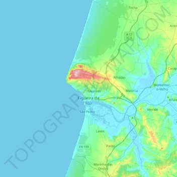
Name: Figueira da Foz topographic map, elevation, terrain.
Location: Figueira da Foz, Coímbra, Portugal (40.01256 -8.90924 40.32688 -8.69988)
Average elevation: 26 m
Minimum elevation: -3 m
Maximum elevation: 250 m
Other topographic maps
Click on a map to view its topography, its elevation and its terrain.
Lares
Portugal > Coímbra > Figueira da Foz > Vila Verde
Lares, Vila Verde, Figueira da Foz, Coímbra, 3090-641, Portugal
Average elevation: 14 m
Oliveira do Hospital
Oliveira do Hospital, Coímbra, Portugal
Average elevation: 413 m
Ega
Portugal > Coímbra > Condeixa-a-Nova
Ega, Condeixa-a-Nova, Coímbra, Portugal
Average elevation: 75 m
Sepins
Portugal > Coímbra > Sepins e Bolho
Sepins, Sepins e Bolho, Cantanhede, Coímbra, 3050-566, Portugal
Average elevation: 81 m
Marianas
Portugal > Coímbra > Figueira da Foz > Marianas
Marianas, Bom Sucesso, Figueira da Foz, Coímbra, 3090-448, Portugal
Average elevation: 52 m