
La Palma topographic map
Interactive map
Click on the map to display elevation.
About this map
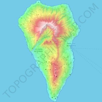
Name: La Palma topographic map, elevation, terrain.
Location: La Palma, Santa Cruz de Tenerife, Canary Islands, Spain (28.45270 -18.00723 28.85789 -17.72422)
Average elevation: 295 m
Minimum elevation: 0 m
Maximum elevation: 2,410 m
In a programme transmitted by the British Broadcasting Corporation BBC Horizon broadcast on 12 October 2000, two geologists (Day and McGuire) cited La Grieta as proof that half of the Cumbre Vieja had moved towards the Atlantic Ocean (Day et al. 1999, and Ward and Day, 2001). They postulate that this process was driven by the pressure caused by the rising magma heating water trapped within the structure of the island. They hypothesised that during a future eruption, the western flank of the Cumbre Vieja, with a mass of approximately 1.5 x10¹⁵ kg, could slide into the ocean. This could then potentially generate a giant wave, known as a "megatsunami" around 650–900 m (2,130–2,950 ft) high in the region of the islands. The wave would radiate out across the Atlantic and inundate much of the eastern seaboard of North America about 7 hours later, many of the islands in the Caribbean and northern coasts of South America between six and eight hours later. They estimate that the tsunami will have waves possibly 50 m (164 ft) or higher causing massive devastation along the coastlines. Modelling suggests that the tsunami could inundate up to 25 km (16 mi) inland – depending upon topography. The basis for Ward and Day (2001) modelling the collapse of a much larger portion of the western flank than what the currently visible surface crack indicates as being potentially unstable, was based on geological mapping by Day et al. (1999). In this paper they argue that a large part of the western flank has been constructed in the scar of a previous collapse and therefore sits upon unstable debris.
Other topographic maps
Click on a map to view its topography, its elevation and its terrain.
Castillo de Almodóvar del Río
Spain > Andalusia > Almodóvar del Río
Castillo de Almodóvar del Río, Calle Parvas, Almodóvar del Río, Córdoba, Andalusia, 14720, Spain
Average elevation: 102 m
Parets del Vallès
Spain > Catalonia > Vallès Oriental
Parets del Vallès, Vallès Oriental, Barcelona, Catalonia, 08150, Spain
Average elevation: 100 m
Parets
Spain > Catalonia > Priorat > el Masroig
Parets, el Masroig, Priorat, Tarragona, Catalonia, 43736, Spain
Average elevation: 102 m
Escorca
Spain > Balearic Islands > Serra de Tramuntana
Escorca, Serra de Tramuntana, Balearic Islands, 07315, Spain
Average elevation: 382 m
Alegranza Island
Alegranza Island, Teguise, Las Palmas, Canary Islands, Spain
Average elevation: 39 m
La Nava
Spain > Andalusia > Sierra de Huelva
La Nava, Sierra de Huelva, Huelva, Andalusia, Spain
Average elevation: 490 m
Zufre
Spain > Andalusia > Sierra de Huelva
Zufre, Sierra de Huelva, Huelva, Andalusia, Spain
Average elevation: 425 m
Olivenza
Spain > Extremadura > Llanos de Olivenza
Olivenza, Llanos de Olivenza, Badajoz, Extremadura, Spain
Average elevation: 257 m
Pollença
Spain > Balearic Islands > Serra de Tramuntana
Pollença, Serra de Tramuntana, Balearic Islands, Spain
Average elevation: 115 m
Gorafe
Spain > Andalusia > Comarca de Guadix
Gorafe, Comarca de Guadix, Granada, Andalusia, 18890, Spain
Average elevation: 816 m
Mijares
Mijares, Ávila, Castile and León, 05461, Spain
Average elevation: 932 m
Cabargo
Spain > Cantabria > Ribamontán al Monte
Cabargo, Ribamontán al Monte, Cantabria, 39794, Spain
Average elevation: 128 m
Algeciras
Spain > Andalusia > Campo de Gibraltar
Algeciras, Campo de Gibraltar, Cádiz, Andalusia, Spain
Average elevation: 77 m
Soil
Spain > Autonomous Community of the Basque Country > Montaña Alavesa/Arabako Mendialdea
Soil, Arraia-Maeztu, Montaña Alavesa/Arabako Mendialdea, Álava, Autonomous Community of the Basque Country, 01207, Spain
Average elevation: 898 m
Autonomous Community of the Basque Country
Autonomous Community of the Basque Country, Spain
Average elevation: 454 m
Gabia Grande
Spain > Andalusia > Comarca de la Vega de Granada > Las Gabias
Gabia Grande, Las Gabias, Comarca de la Vega de Granada, Granada, Andalusia, 18110, Spain
Average elevation: 695 m
Mara
Spain > Aragon > Comunidad de Calatayud
Mara, Comunidad de Calatayud, Zaragoza, Aragon, Spain
Average elevation: 773 m
Grazalema
Spain > Andalusia > Sierra de Cádiz
Grazalema, Sierra de Cádiz, Cádiz, Andalusia, Spain
Average elevation: 771 m
Macael
Spain > Andalusia > Valle del Almanzora
Macael, Valle del Almanzora, Almeria, Andalusia, 04867, Spain
Average elevation: 839 m
Badajoz
Spain > Extremadura > Tierra de Badajoz
Badajoz, Tierra de Badajoz, Badajoz, Extremadura, Spain
Average elevation: 261 m
Jun
Spain > Andalusia > Comarca de la Vega de Granada
Jun, Comarca de la Vega de Granada, Granada, Andalusia, 18213, Spain
Average elevation: 776 m
Alaminos
Alaminos, Guadalajara, Castile-La Mancha, Spain
Average elevation: 1,049 m
Legazpi
Spain > Autonomous Community of the Basque Country
Legazpi, Gipuzkoa, Autonomous Community of the Basque Country, Spain
Average elevation: 548 m
la Roca del Vallès
Spain > Catalonia > Vallès Oriental
la Roca del Vallès, Vallès Oriental, Barcelona, Catalonia, 08430, Spain
Average elevation: 187 m
Cenicientos
Cenicientos, Community of Madrid, 28650, Spain
Average elevation: 715 m
Salardú
Spain > Catalonia > Val d'Aran
Salardú, Naut Aran, Val d'Aran, Lleida, Catalonia, 25539, Spain
Average elevation: 1,596 m