
Make a donation
Gear up for your next adventure:
As an Amazon Associate, this site earns from qualifying purchases at no extra cost to you.
Mancos topographic map
Click on the map to display elevation.
Make a donation
Gear up for your next adventure:
As an Amazon Associate, this site earns from qualifying purchases at no extra cost to you.
Mancos
Mancos, is the main district of the Province of Yungay. It is located in the central part of the Callejon de Huaylas, in the right margin of the Rio Santa, snow at the foot of the colossus that is Mount Huascaran dominant eastern side and whose melting born Mancos River crossing from east to west to flow into the Rio Santa. Their location is roughly as follows: 9 ° -36 "S latitude and 77 ° 43 '- 28" longitude west of Greenwich. Its altitude is 2.575 metres above sea level.
Make a donation
Gear up for your next adventure:
As an Amazon Associate, this site earns from qualifying purchases at no extra cost to you.
About this map
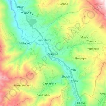
Name: Mancos topographic map, elevation, terrain.
Location: Mancos, Province of Yungay, Ancash, Peru (-9.24645 -77.72090 -9.13199 -77.58882)
Average elevation: 3,016 m
Minimum elevation: 2,308 m
Maximum elevation: 4,344 m
Make a donation
Gear up for your next adventure:
As an Amazon Associate, this site earns from qualifying purchases at no extra cost to you.
Other topographic maps
Click on a map to view its topography, its elevation and its terrain.
Huaraz
Huaraz ([waˈɾas]) (from Quechua: Waraq or Warash, "dawn"), formerly designated as San Sebastián de Huaraz, is a city in Peru. It is the capital of the Ancash Region (State of Ancash) and the seat of government of Huaraz Province. The urban area's population is distributed over the districts of Huaraz and…
Average elevation: 4,068 m
Laguna Palcacocha
Peru > Ancash > Independencia
Palcacocha is located at 9°23′49″S 77°22′47″W / 9.39694°S 77.37972°W / -9.39694; -77.37972 in the Ancash Region in Cordillera Blanca at an elevation of 4,566 m, just below the summits of Palcaraju (6,274 m) and Pucaranra (6,156 m). The lake is one of several lakes supplying the town Huaraz…
Average elevation: 4,857 m
Make a donation
Gear up for your next adventure:
As an Amazon Associate, this site earns from qualifying purchases at no extra cost to you.
Viewpoint crack in mountains shaped like the map of Peru
Average elevation: 4,202 m
Make a donation
Gear up for your next adventure:
As an Amazon Associate, this site earns from qualifying purchases at no extra cost to you.
Make a donation
Gear up for your next adventure:
As an Amazon Associate, this site earns from qualifying purchases at no extra cost to you.
Make a donation
Gear up for your next adventure:
As an Amazon Associate, this site earns from qualifying purchases at no extra cost to you.
Jirishanca
The altitude of 6125 isn't likely as other data from available digital elevation models show lower elevations: SRTM yields 6028 metres and TanDEM-X 5734 metres. The height of the nearest key col is 5610 meters, leading to a topographic prominence of 484 meters. Jirishanca is considered a Mountain according to…
Average elevation: 5,198 m
Make a donation
Gear up for your next adventure:
As an Amazon Associate, this site earns from qualifying purchases at no extra cost to you.
Make a donation
Gear up for your next adventure:
As an Amazon Associate, this site earns from qualifying purchases at no extra cost to you.
Make a donation
Gear up for your next adventure:
As an Amazon Associate, this site earns from qualifying purchases at no extra cost to you.
Make a donation
Gear up for your next adventure:
As an Amazon Associate, this site earns from qualifying purchases at no extra cost to you.