Geolocate

Dhakmar topographic map

Interactive map

Click on the map to display elevation.

About this map

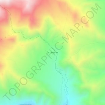
Name: Dhakmar topographic map, elevation, terrain.

Location: Dhakmar, Dalome, मुस्ताङ, Gandaki, Népal (29.07085 83.85768 29.11085 83.89768)

Average elevation: 3,952 m

Minimum elevation: 3,571 m

Maximum elevation: 4,442 m

Other topographic maps

Click on a map to view its topography, its elevation and its terrain.

Barhagaun Muktikhsetra

Népal > Gandaki > मुस्ताङ

Barhagaun Muktikhsetra, मुस्ताङ, Gandaki, 33100, Népal

Average elevation: 4,743 m

Kāgbeni

Népal > Gandaki > मुस्ताङ

Kāgbeni, Barhagaun Muktikhsetra, मुस्ताङ, Gandaki, Népal

Average elevation: 3,101 m

Jharkot

Népal > Gandaki > मुस्ताङ

Jharkot, Barhagaun Muktikhsetra, मुस्ताङ, Gandaki, 33100, Népal

Average elevation: 3,653 m

लोमान्थाङ

Népal > Gandaki > मुस्ताङ

लोमान्थाङ, मुस्ताङ, Gandaki, Népal

Average elevation: 4,949 m

Muktinath

Népal > Gandaki > मुस्ताङ > Ranipauwa

Muktinath, Barhagaun Muktikhsetra-01, Ranipauwa, Barhagaun Muktikhsetra, मुस्ताङ, Gandaki, 33100, Népal

Average elevation: 3,965 m