
लोमान्थाङ topographic map
Interactive map
Click on the map to display elevation.
About this map
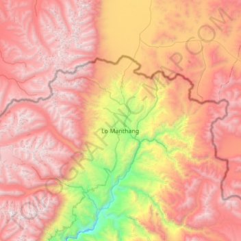
Name: लोमान्थाङ topographic map, elevation, terrain.
Location: लोमान्थाङ, मुस्ताङ, Gandaki, Népal (29.07381 83.65573 29.33125 84.20240)
Average elevation: 4,949 m
Minimum elevation: 3,104 m
Maximum elevation: 6,364 m
Other topographic maps
Click on a map to view its topography, its elevation and its terrain.
Barhagaun Muktikhsetra
Barhagaun Muktikhsetra, मुस्ताङ, Gandaki, 33100, Népal
Average elevation: 4,743 m